BIKEPGH MESSAGE BOARD ARCHIVE

« Back to Archive
92

New TRHT Map, Jail Trail "Hazelwood Segment"

Received a new 2012 Three Rivers Heritage Trail map via snail mail this morning, a very nice map.


I was very excited to see a Hazelwood segment extending the Jail Trail to what seems like at least halfway between Swinburne Street and the Duck Hollow Trail, with an expected date of Summer 2012. And it shows the Nine Mile Run connection well.


very very cool.


vannever
2012-05-17 04:05:44

Yeah, I noticed that as well. They are having their "Trail Mixer" at the Robot Roundhouse and recommended taking the new portion of the trail there. I am really excited about it as I can get to Duck Hollow fairly easily from my house. Now if we can get Frick Park's trails paved or the limestone maintained we are in business.


rsprake
2012-05-17 12:37:44

Once on the board someone put up some good pics of the Homestead trail section "candlestick" markers, anybody remember what thread that was in?

Or could someone get some good current pics of them? I have a little meeting Tues and I'd like to have some pics. Super thanks in advance.


edmonds59
2012-05-17 12:48:57

I mentioned the candlestick section at the MOVEPGH public drop in yesterday. The consultant was pleasant, but he had no idea what I was talking about - and he himself was a 'weekend' cyclist. Sigh.


marko82
2012-05-17 13:16:18

Edmonds59 - I have this one:


vannever
2012-05-17 17:19:27

Thanks! That's a start.


edmonds59
2012-05-17 17:38:53

Last time I was down there, a bunch of them had be knocked off.


ndromb
2012-05-17 17:56:43

They were replaced about 3 weeks ago. A few have been knocked down since.


durishange
2012-05-17 18:24:52

It's going to be a losing battle. Someone can't hold a line around the corners.


rsprake
2012-05-17 18:53:06

We need something there to draw driver's attention to the middle of their lane. Kind of like the image of a fly they put in a urinal to keep the pee off the floor.


roadkillen
2012-05-17 19:49:26

Replacing the candlesticks (can't think of the official name) will be an ongoing maintenance task for the Steel Valley Trail Council. We just placed an order for a bunch so we'll have back up for the future.


sarapgh2
2012-05-17 20:10:30

> It's going to be a losing battle. Someone can't hold a line around the corners.


I wonder if it might be one of those wacky teenage pranks to go run down the candlesticks? Better than mailboxes, I suppose...


epanastrophe
2012-05-17 20:37:19

Better than mailboxes, I suppose...


Back when dinosaurs roamed the earth, my parents(and numerous neighbors) had their mailbox run over repeatedly...apparently, by a tall vehicle with a white-painted bumper, based on the damage to the poles.


My dad decided that enough was enough, so sank 10' of telephone pole into a few hundred pounds of concrete, and nailed the mailbox on top.


A few days later, they found a white-painted bumper off a large truck wrapped around the pole, and no-one ever complained about their mailbox being run over again.


I suppose similar tactics would be frowned upon these days...


reddan
2012-05-17 20:46:13

When I lived along Arona Road in New Stanton, we had a spate of bashed mailboxes one summer. Looked to be the work of someone hanging a baseball bat out the window. I secured a piece of 8-foot rebar, and pounded into the ground at about 30 degrees off true, facing upstream. No problem for the mailman; to him it was just a tilted signpost three feet up from the mailbox. A few nights later, we heard ka-SMASH, and found a bunch of busted side window glass by the mailbox, and the rebar was standing close to straight up.


Never had another problem with busted mailboxes.


stuinmccandless
2012-05-17 21:50:59

they have what in the urinals? @roadkillen


tabby
2012-05-18 14:31:47

@Tabby: try this. specifically, look for the (3) part.


hiddenvariable
2012-05-18 14:36:10

I was going to recommend that the front three or so have some rebar in them, a la Stu's description.


For some reason, the first thing that came to mind when HV proposed his center-of-lane-eye-catcher was pictures of naked boobies on the road done in perspective like those sidewalk-chalk-art photograph spam emails. I have no idea why, but people of all inclinations seem to obsess over boobs, so it's the most eye-catching thing I could think of. Getting PADOT to paint boobies on the road seems more likely than getting them to paint bike lanes anyway. It'd be cheaper than designing complete streets or street diets too. Could be a bandaid until we get a better transportation bill.


ejwme
2012-05-18 15:28:58

@edmonds, Bikeygirl took some shots of the bike lane down in Homestead and will PM them to ya.


marko82
2012-05-18 17:31:52

EDMONDS!


Here are the pics of the Bike Lane in Homestead....


bikeygirl
2012-05-18 19:23:17

Awesome! thanks!


edmonds59
2012-05-18 19:25:23

Three Rivers Heritage Trail to be extended


The 2-mile extension will run from the Hot Metal Bridge through the former mill property now owned by a partnership made up of Pittsburgh charitable foundations known as Almono. It will end at a trailhead on Hazelwood Avenue.


The Heinz Endowments, one of the Almono partners, is funding development of the trail, which will coincide with redevelopment of the 178-acre steel mill site.


Friends of the Riverfront has hired CDM Smith engineers to design the trail.


Does anyone have any more clear information on this? The Trail Mix(er) page says to "Or arrive on foot or by bike using the new Hazelwood segment of the Three Rivers Heritage Trail opening spring 2012" but the article says they only now hired engineers to design the trail.


This is what the road from second ave looks like at this point. The gate is open but the sign says no trespassing.


Trail or illegally trespassing


rsprake
2012-05-22 15:57:03

I believe the trail starts at the corner of Hot Metal Bridge and 2nd Avenue. From there it goes around a big parking lot and along the river. Take another look at the map and you'll see what I mean. I haven't been able to try it myself yet but I have noticed what looks to be the new trail when I've passed by that corner recently. Compared to the location of your photo, the new trail should be closer to the river.


brent
2012-05-22 16:46:14

I've looked on Google Maps. I just can't get a sense if it's done, almost done or still being planned. Everything I read says something different.


rsprake
2012-05-22 16:55:54

This new trail segment has rekindled my interest in seeing a better connection to Greenfield. I have pondered this before and my best solution would be to make a connection from the Hazelwood Greenway along the hollow that runs between Bud Hammer field and the adjacent playground. This short segment, along with improvements to the greenway, would take advantage of terrain and make a great back entrance to Greenfield. While connecting to Sylvan Avenue at entrance to the greenway is ok for now, I would eventually like to see a trail branching off from the intersection of 2nd Avenue and Greenfield Avenue (behind the "Greenfield" water tank. I've tried to plot this all out with Google Maps. I've also seen a similar idea proposed as part of a Carnegie Mellon Remaking Hazelwood report. I wonder if any work is being done on this plan.


brent
2012-05-22 17:18:15

I have personally seen what looks like a new crushed stone surfaced trail branching off the corner of 2nd Avenue and Hot Metal Bridge. I've checked the Google Maps and it does not show up there, so I'm assuming this is the new segment. I would check it out on my way home from work today but I won't have time.


brent
2012-05-22 17:24:53

Friends of the Riverfront posted a message on April 23 on the Three Rivers Heritage Trail list that said "Construction to begin next week on connecting Eliza Furnace at Hot Metal through the ALMONO site to Hazelwood Avenue. This will add another 1.5 miles of trail and connect Hazelwood with downtown Pittsburgh and beyond."


I'm guessing they started building it at the end of April and expect it to be open by June 16th for the Trail Mixer.


Based on the map Vannevar posted at the top of this thread, I expect the trail would be on or near the grassy strip shown in Street View here.


steven
2012-05-22 17:44:32

I wonder what the planned connection is. The current Hot Metal Bridge pedestrian ramp is not setup to handle heavy trail traffic.


rsprake
2012-05-22 17:50:03

rsprake, put up some info on that "trail mixer" if you can. I got a quick glimpse of the poster but I didn't get all the info. Thx!


edmonds59
2012-05-22 18:26:41

Thanks.

Oh dang 50 beans! This is one of those things.


edmonds59
2012-05-22 19:04:57

There is a late night option for $15 but yeah, it's their fund raising party.


rsprake
2012-05-22 19:07:43

I live close, I go through Hazelwood. I use the HMB. And I woudl surely buy a $50 ticket if they were going to put a ramp from Bates to the jail trail. I miss that so much!


mick
2012-05-22 19:18:05

I rode the Hazelwood Connector yesterday. The surface is currently crushed stone bedding in preparation for the final surface. It could be crushed limestone but I think it's more likely to be asphalt. There were no fences, gates or signs of any type blocking my way.


From the south side of Hot Metal Street it runs towards the river around the parking lot. It parallels the rail past the Monongahela Connector Railroad round house, under the railroad bridge and, shortly thereafter, ends at the road that connects with Second Avenue just before the LTV Mill site.


There is a lot of empty back there and a maze of "roads" so I could easily see the trail extending as far as Hazelwood Ave. or Tecumseh St. but I could not see any evidence of trail construction beyond LTV.


kordite
2012-05-23 11:37:26

Your description makes it sound as though the map at the top of this thread does not match reality? Runs closer to the river? And does it actually end near Flowers Street?


edmonds59
2012-05-23 12:04:30

It runs on the 2nd Avenue side of the single line track. Not that close to the river.


The map looks like it goes to about where I describe it and then goes up to 2nd Avenue itself, following the seldom used road instead of any created trail.


I created a map in Google Maps:


http://maps.google.com/maps/ms?msid=209889901052155265597.0004c0b3740af85718065&msa=0&ll=40.419443,-79.951544&spn=0.032803,0.064974


I made a mistake in extending the trail past Hazelwood Ave where I suspect it will end at the noted parking lot. I'll adjust the map when I get the chance.


kordite
2012-05-23 13:03:45

I personally don't see why they couldn't have the trail go UNDER the Hot Metal Bridge and then snake up alongside it to meet up with the ramp that leads down to the Second Avenue sidewalk. I'm willing to guess this is due to property/ROW issues pertaining to the chemical corporate building (name escapes me) adjacent to Hot Metal.


And I think that's unfortunate as that is the better PRACTICAL alignment by avoiding a road crossing.


Additionally, I also think an aligment using the Eliza Furnace trailhead parking lot with a new ramp leading down from the old railroad viaduct down to the driveway in the ALMONO site would also be practical. Again however, I'm guessing this was ruled out because it would involve the loss of UPMC parking spaces, construction of a new ramp, and (I'm guessing) sharing of an active road for the trail.


impala26
2012-05-24 00:22:01

Some photos from yesterday. Looks like they plan on directing you to the trail using the cross walk.


Untitled


Here is the new trailhead. They have a lot of work to do.


Untitled


I found these stairs that lead to the river!


Untitled


rsprake
2012-05-24 13:27:07

@edmonds59 I say at some point a celebration at Jozsa Corner is in order.


Yes! Please! Maybe meet at dino 6 pm Friday?


mick
2012-05-24 17:45:55

I'm thinking about the Bakery Square BBQ this Fri. But sometime.


edmonds59
2012-05-24 17:48:41

@impala26 & rsprake: the trail splits and includes a path that goes under the bridge. to get to the hotmetal bridge ramp from there involves a few steps next to the thermofisher building. the steps are far enough apart that riding down them might be easy -- slight inconvenience on the way up though


melange396
2012-05-24 18:16:37

I finally read this thread today. I wouldn't mind checking this out with someone tomorrow evening after meeting at dippy. People working on this trail should be gone by then. Perhaps then heading to bakery square from there...


stefb
2012-05-24 18:41:34

for what its worth, the trail is clearly not complete. its got a very dusty dirt top-cover (instead of crushed limestone or asphalt) and has some serious craters (moon reference for those playing along at home ;-p ). in some places, its not quite clear which way is the 'trail' vs some access road or whatever.


melange396
2012-05-24 18:58:56

If they're prepping the trail for paving or whatever, riding through there and making tire ruts might not be the coolest thing in the world to do.


salty
2012-05-24 19:36:22

And, as mentioned over in the Tag-O-Rama thread, there's now a temporary fence across the trail that prevents you from going further than the parking lot.


mrdestructicity
2012-05-24 19:37:21

ok, i went out today to start correcting my woeful lack of knowledge about these trails.


I took forward to the 9 mile run trail then to duck hollow. I didn't go on the new section, I just took 2nd ave - but inbetween there are 5 sets of tracks to cross which is not really my idea of fun. is there some plan to eventually bridge across the tracks there? looks expensive :(


salty
2012-06-02 20:42:55

Heh, try doing it with loaded panniers :P


This will probably never happen, but...


It would be cool if they could just do a kind of raised trail section like they do with roads so there's a partially flush surface with the tracks


sgtjonson
2012-06-02 21:18:08

hm... i assume they'd be required to do automatic gates if they did that; i wonder how the cost compares to constructing a bridge.


BTW, on the way back I thought I'd give flowers/kilbourne/tesla a shot. I made it up to tesla but that is super steep and it killed my spirit so I walked it. I was on my CC, I think I'll go back with my LHT with way lower gears and give it another go. I think I need to work some more hills into my usual riding. (BTW, my calculations are ~10% grade for 0.5 miles followed by ~16% grade for 0.16 miles)


salty
2012-06-02 22:21:47

The Duck Hollow crossing could be done cheaply I think but I have a feeling they will overdo it in the name of safety and a better connection. I don't doubt it's coming, it's just a matter of when.


For what it's worth I have yet to see a train at that crossing.


rsprake
2012-06-03 00:17:47

Train speed in that area is on the high side of 35-40 mph. That's the main line between Pgh and points east: Harrisburg, Phila, NYC, DC. There are *lots* of trains.


The solution I want to see is a Ft Duquesne Bridge type of sidewalk and switchback attached to the Glenwood Bridge to get across the tracks. Maybe the river, too, but at least the tracks. I'm sure it won't be cheap, but I suspect 7 digits, not 8. Does anyone have figures on what the FtDuqBr walkway cost?


stuinmccandless
2012-06-03 01:42:34

A sidewalk on the Glenwood bridge won't get you to and from Duck Hollow. A simple bridge like the ones they installed over the tracks on the Steel Valley trail would make more sense for Duck Hollow.


Like I said, I have yet to ever see a train moving at any sort of speed through there. I am not denying it happens, but I haven't witnessed it. The only time I've seen any activity it was in the yard and at about 2 mph. Now across the river on the set of tracks in Homestead there is lots of train activity.


rsprake
2012-06-03 13:36:54

Getting a bridge over to Duck Hollow is not an easy task. The little flyovers on the Steel Valley Trail to cross maybe 3 tracks cost several million dollars, each. To cross 8 tracks will be much more, in addition to negotiating right-of-way, clearance, land use, etc. Costs for engineering a switchback are typically even more. I've never seen any actual numbers on what it would take to cross Duck Hollow, this is just my opinion knowing costs on the other projects.


sarapgh2
2012-06-04 14:38:16

Would an at grade crossing with a signal be more expensive?


rsprake
2012-06-04 14:57:58

An at-grade crossing would add several steps to the planning, design, operation and maintenance. It'd be difficult politically, because politicians don't like navigating bureaucracy.


A bridge, though much more expensive - now and in 15 or 20 years when rehab is needed -, gets the gold-plated shovels in the ground faster.


sloaps
2012-06-04 15:30:53

Not sure how an at-grade crossing would work there. The tracks aren't all parallel and it's a long distance (relatively) to cover. The bridge option is fast? Not sure about that either. The big issue in getting a lot of the trail connections (referring to bridges and walkways, not path) done around Pgh was lack of money. People don't throw money at these things, however good it sounds, and funding used (state and fed $$) is getting axed all over the board. If you know of a private donor that wants to put 10M into a bike project, I'm sure it could get done fast (5 years:):)


Edit: obviously, negotiating land use and rights-of-way have been a huge issue too.


sarapgh2
2012-06-04 16:18:13


rsprake
2012-06-04 16:18:16

So the little festival at the end of this trail seemed like a success. The neighborhood is into this. After looking briefly at the Almono plan, I have questions popping into my head, unfortunately about 14 hrs too late. The last thing I want to do at 7 pm on a beautiful Friday evening is think like an architect, this is what separates me from actual "successful" people.

Anyway, since there is now a safe route to commute from Hazelwood to many places for jobs, it seems like what Hwood needs is a garage door community bike shop. If somebody could find a resident who could get fired up and passionate about this, then tap 2 grand, or 1 grand, of that development money, and set somebody up in a tiny shop, it would be bigger bang for buck than piling $$$$ into roads on that old site. Is it possible anything like that is already going on? Anybody know anybody? Unfortunately I'm just an old fart who gets these ideas that go up like bottle rockets then completely cease to exist once they're done.


edmonds59
2012-06-16 13:47:29

What does the term "Almono" mean? Is it an acronym? Seriously. TIA. V.


vannever
2012-06-16 14:26:12

I have no idea, "one Al", maybe? But from a quick look, it may be Spanish for "stale 1990's developer-think".


edmonds59
2012-06-16 14:44:40

Courtesy of the Google machine:


" In 2002, Almono LP (the name is derived from the three rivers in Pittsburgh - Allegheny Monongahela and Ohio), a consortium of four local foundations (Benedum Foundation, Heinz Endowment, Richard King Mellon Foundation and McCune Foundation), purchased the 178 acre site as one parcel for $10 million. RIDC is the managing partner for this group of investors."


http://almono.org/about-almono/history


atleastmykidsloveme
2012-06-16 15:30:46

Almono's sure got down the science of using buzz words to make itself seem like they're concerned with more than profits.


So far, I'm not particularly impressed with Riverfront development. It's basically been businesses with little tracks of "public access" land on the side. I could be wrong about this, but they're not places people spend any significant amount of time at.


I'd also be interested in mixed-income housing, but I don't even see any buzzwords that point to that from Almono's site. So what happens is, you build a big development that nobody in the already present community has access to, 2nd Ave gets more traffic, Grenefield Ave gets more traffic, housing prices might even rise in Hazelwood, displacing residents already there


I'm not entirely sure that's going to be the case though. I think 2nd Ave is going to be a pretty significant division between these two places, but I could be wrong about that


sgtjonson
2012-06-16 15:45:50

"stale 1990's developer-think"


But Edmonds, they are putting a road right next to the river! You know, so you can look at it from the car, but not actually be able to get to it. Besides, the people living spaces are going to be pushed all the way down to the far end of the development, so why would anyone want to get to the river?


marko82
2012-06-16 15:48:24

Hopefully they are taking a better approach than "anything is better than what's there" like they seem to have done in the South Side. The hotel being built next to Hofbrauhaus is an example of everything I hate about modern real estate development. No matter what happens the trail is there to stay and I am really happy about that for purely selfish reasons. It gives me access to an almost car free commute to work if I choose to go a few miles out of my way.


rsprake
2012-06-16 16:00:25

It sure would be nice if they *didn't* just do a "hey it worked across the river, let's do the same thing here" approach, but took an entirely new approach.


I do have serious reservations about the connectivity of that trail to anything else. There are two ways to get to it from the rest of the world on the Hot Metal end, and neither is acceptable. One is to cross Hot Metal St right at the busy corner of Second Ave. The other is to wiggle around the back or side of that first building, on a path clearly intended for pedestrians only.


Speaking as someone who has a choice between a stream jump or climbing a 53-step staircase on a daily basis, I think I would prefer either of those to dodging cars at that corner on a daily basis.


stuinmccandless
2012-06-16 17:09:30

Pierce, I agree with about 80% - 90% of what you're saying.

I have no problem with someone coming in and trying to make a profit. In fact I hope someone does make a profit and I hope all the residents of Hwood make some money. But I see way too much "Homestead II" and not enough benefit to the residents. Laying down some roads in a blue-sky scheme with no solid tenants accomplishes nothing fast.


edmonds59
2012-06-16 17:45:57

Stu, I don't think the corner will be "that" bad but I do hope for a better connection eventually. They have added signage pointing out that there is a trail crossing and the pedestrian signal will stop the right turn on red. I think my route will be to take the trail under the hot metal bridge through the business park to the old detour.


rsprake
2012-06-16 18:14:33

Some commentary on existing Hazelwood: Nearly every building along Second Ave can be guaranteed to have old wiring, old plumbing, old roof/windows, lead paint, an old furnace, and sub-standard insulation. What would really help Hazelwood is if these were either rehabbed or replaced. Otherwise, all you get is Yuppieville over on one side of the tracks, and Decrepitville on the other. That will, of course, take money, and I don't have any bright ideas for how to do this without pushing out the existing residents.


stuinmccandless
2012-06-16 19:38:06

Regarding the Hazelwood 'trail'. I have run and biked in the LTV brownfield for years. I checked it out this morning after reading the PG story. That 'trail' is an existing road that is part of the site. It is in really bad shape -full of potholes and cracks and continues to have truck traffic on it. One end dead ends with no way of getting on the Glenwood bridge and the other dumps you in the rather busy & uncontrolled intersection of Greenfield and 2nd ave. It is a real stretch to call this a bike trail. All they did was sweep the broken glass off the road and put up a sign with a graphic of a bike on it. No points from me on this one.


jlfunder
2012-06-17 00:16:23

^I was waiting for someone else to say that. We enjoyed our ride yesterday nonetheless. I know how hard and expensive it is to do trails, but I was surprised by the lack of signage and the lack of cutting back the weeds for the right hand lane of the supposedly 2 way bike trail lanes.


eta: @jfunder, the actual trail (with crushed limestone for a bit) does go to the left and follows the train tracks so you can come out near the Hot Metal bridge, not dumping out at second ave.


tabby
2012-06-17 01:29:47

I guess it is "better than nothing" but the first thing I said to fellow riders after returning from it is that it is not great. The road surface is horrible.. Worse than the abandoned turnpike. The crushed limestone on parts of it is pretty deep. I guess I understand why there are bike lane marking on it now, if there really is truck traffic that continues to use it. I can see a lot of people with under inflated tires getting flats. Hopefully it is a work in progress.


stefb
2012-06-17 11:39:32

That area is going through redevelopment so it's not permanent on purpose. I am sure it's going to be reconfigured a few times before it's finished.


They are going to have to do something about that pedestrian crossing at Hot Metal and 2nd Ave though. The pedestrian signal is triggered at the same time as a green to turn right on red and even with bright flashing lights no one yielded to three of us in the crosswalk.


rsprake
2012-06-18 17:04:37

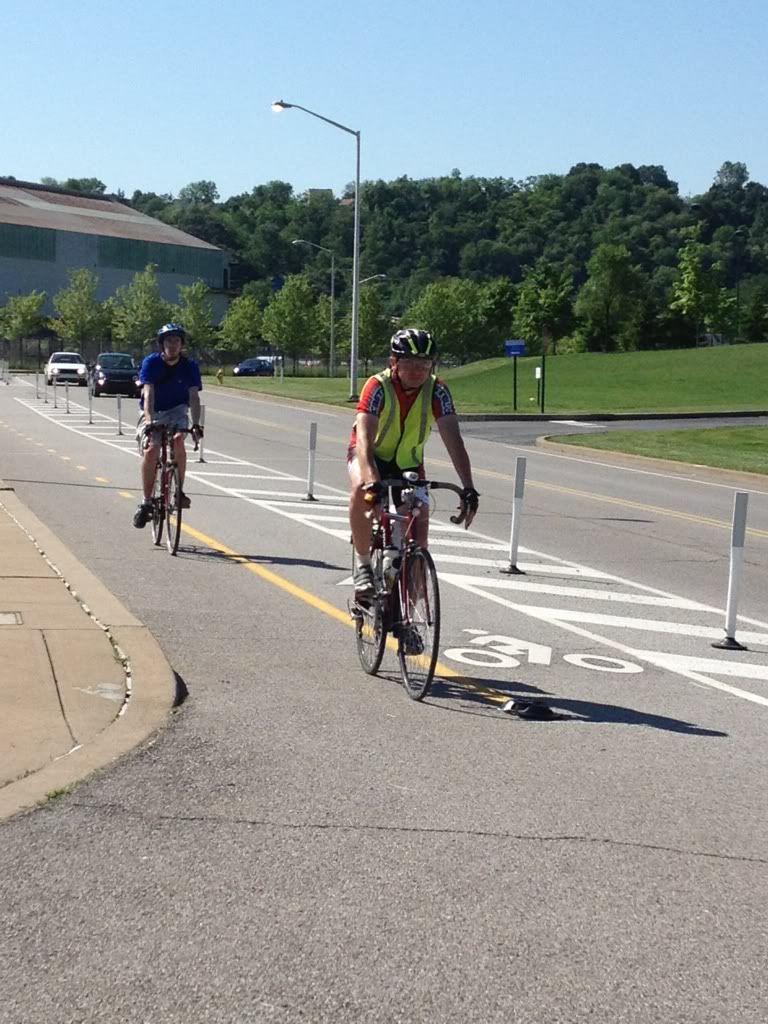
As somebody who rides 2nd Ave to the Glenwood Bridge four, five days a week...


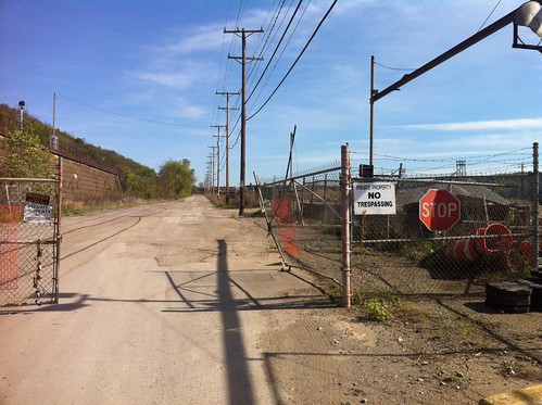
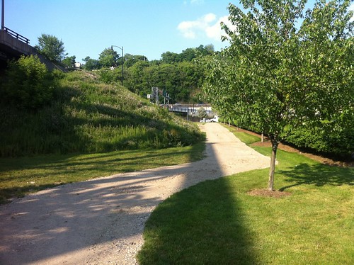
The Trail is actually better than the pavement in Hazelwood used to be. (thinking of segments that were like sine waves) (They're still working on the new pavement, might even be doing fancy stuff around the utility covers to make them stick out less, it looked like tonight)


That being said, I'm still not sure if it's something I'll use on a regular basis. I'm usually dropping out of the Panther Hollow trail, which means I have to backtrack to the bridge.


Coming back to the city, you have two lanes on Second Ave, which I always take a full one, and don't ever have any issues.


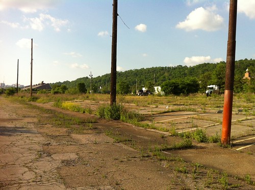
Leaving the city, although the trail is nice in avoiding the single lane 2nd Ave, it dumps you on Hazelwood Ave and 2nd, and it's still annoying dealing with traffic until you hit the bridge.


So if I have to backtrack to the HMB, I could just as easily go over the river and avoid 2nd Ave altogether, which I haven't yet been doing due to the having to backtrack/train issues.


It would be nice if either of the dang trails were finished on either side. There's also no signage on 2nd Ave that lead to the trail. There is a sign on Hazelwood, but if you weren't looking for it, I could see it easily being missed.


I think it's a step in the right direction, especially for people coming from Hazelwood into the city or cyclists with less comfort on the road. For me though, it's just another half-complete trail that doesn't really do me too much good.


sgtjonson
2012-06-19 01:55:52

In the Glass Half Full department, I see the completion of the trail as a good thing; that was progress. Now we have to deal with the other powers that be for things like traffic enforcement, signage, poor intersections. It's the nature of the jungle clearing world of early 21st century cycling. One piece at a time. This was a big piece.


stuinmccandless
2012-06-19 11:21:09

^+1. For someone who wants to get to a job in town from Hwood or Greenfield by bike, the trail is perfectly functional.


edmonds59
2012-06-19 11:41:26

^ or get to a grocery store!


marko82
2012-06-19 11:55:34

I rode back out this way on Sunday, the trail thing piqued my curiosity about this whole area, rode from home to the McKeesport bridge, flattest dang ride I've been on in aeons. Rode the gravel railroad to get to Homestead and on (aside, fk sadcastle anyway). Coming back, sadcastle parking lot to Haysglen, Baldwin, Glenwood bridge.

My observation is that a road diet needs to start at the Glenwood bridge, it seems crazy to bring traffic in to that bend at the end and into Hazelwood at speed.

Also road diet Irvine/Second all the way from Hazelwood to Greenfield Ave, that 2 lane inbound just encourages excessive speeds. Nuts.

I want to go back in time and slap the hell out of any traffic engineer who decided that every possible road should be designed like an interstate highway. Hopefully engineers are getting over that.


edmonds59
2012-06-19 13:25:27

Irvine/ Second Ave is the fastest 25 mph road ever. I never feel safe riding it.


I took the trail today, attempted to take Duck Hollow but the train yard was in use so I back tracked up and over Hazlewood Ave to the trailhead. Someone passed me with a back pack on.


rsprake
2012-06-19 13:44:19

I rode the new Hazlewood segment last Friday and am glad its there but frustrated about the gap between the Steel Valley Trail (the one to Duck Hollow) and Hazlewood Avenue.


There has been a train parked beneath the Glenwood bridge, making it difficult to jump the tracks there to access SR 885. Last Friday I rode through railroad right of way to the Vespucius Street at grade crossing at the Glenwood Yard. Probably not the best idea.


I talked with a railroad engineer about the feasibility and cost of an at-grade crossing under the Glenwood Bridge:


constructing a paved crossing surface of a track is probably going to run $300 per track-foot. Hence a 10-foot wide crossing of one track would be $3,000 for the physical crossing surface. Multiply that by the number of tracks involved. That doesn't address any paving required between the tracks nor does it address matters of providing appropriate warning devices (either passive or active) at the crossing. Naturally, if the railroads agree to a trail crossing at all, they are going to be looking for somebody else to pick up the cost of installation and maintenance of the crossing infrastructure and systems. I doubt that the three railroad companies involved (CSX, Allegheny Valley Railroad and Amtrak) would approve of a trail crossing at this location in a million years. Anytime you do cross at that location, you’re technically trespassing and subject to arrest by a railroad policeman.


2012-06-19 16:39:50

So I'm hearing low-end five digits to get infrastructure put in, and some amount of money, I'm guessing not a huge sum, to maintain a signal system at a grade crossing.


Not exactly chickenfeed, but, well, chickenfeed. A traffic light at a reasonably small corner is $100K.


stuinmccandless
2012-06-19 17:22:02

I'm guessing that warning lights, possibly two gates, and train detection for 8 sets of tracks will be considerably more than a traffic light at a small corner.


I'd guess upper 6 digits/lower 7 digits.


I'm not sure how easy it is to get railroads to approve this, but there might be some cost involved with that, too.


mick
2012-06-19 17:35:16

my understanding is that railroads hate all manner of at-grade crossings, and i would guess it would be easier to collect the money for a giant bridge and get it constructed than to get the various players to agree on an at-grade crossing for that many tracks, especially if there are often cars just sitting there, that they would have to be conscientious about moving. in fact, i suspect the likelihood of equipping every bicycle with a means to fly over the tracks is greater than an at-grade crossing there.


hiddenvariable
2012-06-19 18:09:52

mjost7, thank you for reminding me that there is a "Vespucius St" If we'd taken the map maker's last name instead of his first name, we'd be the United States of Vespucia.


While crossing infrastructure providing a path over 8 sets of railroad tracks would be safer and nicer than trespassing, I'm not sure I'd call it a trail. Thru-way, maybe. Shouldn't trails be just a teensy bit more bucolic than that, perhaps at least as pastoral as the Jail Trail with it's majestic knotweed?


I hope they come up with a better solution.


ejwme
2012-06-19 18:48:33

@HV - agreed.


atleastmykidsloveme
2012-06-19 20:47:26

I mean, if we're keeping with the KISS principle, there's no need to build an entirely new bridge for a bike trail at the Duck Hollow location anyway, as the Glenwood Bridge already crosses all the train tracks and has a separated sidewalk (albeit slightly narrow). I'm fairly certain that a single ramp could be constructed shooting off of the east sidewalk of the Glenwood Bridge towards the Duck Hollow Trail in a fairly simple manner, both in terms of engineering and financing. I'm actually fairly certain that the horizontal clearance at that site is long enough to accommodate for an ADA-compliant ramp that wouldn't require a single switchback (~500 foot lateral/~50 foot vertical). Pair this ramp with another (compact switchback) on the south end/east side of the Glenwood Bridge and you have a seamless connection between Duck Hollow and the South Side Trail/GAP.


The issue with this is that this only serves to connect the existing trails, rather than connecting the Duck Hollow to Hazelwood effectively. Perhaps segregated bike lanes leading down the Glenwood with a new signalized intersection to cross over at either the first street, Alluvian, or further down at Vespucius.


The latter part is obviously still up for discussion, but I think it is wise to use as much infrastructure that's already in place as possible.


impala26
2012-06-19 21:53:11

Impala speaks sense... but don't we have a habit in this City/County/State of being more able to fund new infrastructure than repair existing infrastructure because of the way budgets are? Rehabbing/Refurbing that bridge may be "more difficult" than building something new due to our crazy politics (much the same way a big bridge might be cheaper and easier than a simple at-grade crossing).


ejwme
2012-06-20 14:09:08

"Perhaps segregated bike lanes leading down the Glenwood with a new signalized intersection to cross over at either the first street, Alluvian, or further down at Vespucius."


Definitely Vespucius if at all, people routinely rev up going over the bridge and although they do finally slow down at the bend, they're still making pretty good speed coming into Hazelwood


If we go by Stu's "would you let your kid go there unaccompanied" rule, I'd be pretty weary letting them cross 2nd avenue anywhere near the bridge, crossing or not


sgtjonson
2012-06-20 14:18:15

It's my time to ask something that's probably stupid about the Hazelwood trail, and that's why I've put it here rather than in it's own ostentatious new post.


I was riding on the Hazelwood trail today for the first time and I saw a curious object. Here's a photo:


Can anybody please tell me what this is?


Confession: to me, it looks like the base platform of an apollo lunar lander, something like the photo below - and that's just plain crazy talk of course.


Anybody help a fellow out? TIA.


vannever
2012-07-10 20:14:06

is the nine mile run connection listed on this map bikeable?


imakwik1
2012-07-11 00:56:55

Definitely, it's a little rocky but still ok for road bikes. There's also a short segment on the street to get under the tracks right at the connection.


Here's my track from when I rode through there last month: http://connect.garmin.com/activity/184816483


salty
2012-07-11 01:08:02

Definitely, it's a little rocky but still ok for road bikes. There's also a short segment on the street to get under the tracks right at the connection.


Here's my track from when I rode through there last month: http://connect.garmin.com/activity/184816483


salty
2012-07-11 01:08:55

Today I rode Nine Mile Run today from Frick Park (starting at Lancaster St) to a street just above the Mon River - Old Browns Hill Rd- and intercepted the Duck Hollow Trail. Eminently bikeable, although def. rough in spots. Link to the GPS track: http://www.endomondo.com/workouts/70547380


vannever
2012-07-11 01:11:25