I will be visiting Pitt in a couple of weeks and would like to bring my bike with. Can anyone recommend a good, safe 30-40 mile road route in the area? Also, is there a good source for group rides for the area? TIA
stillmc
2016-06-27 12:27:14
See the Western Pennsylvania Wheelmen site (
http://wpwbikeclub.org/) for a group ride calendar.
jonawebb
2016-06-27 12:58:13
@stillmc, what kind of route are you interested in? Do you prefer trails only or would rather avoid them? City ride or country ride?
chrishent
2016-06-27 13:19:09
@chrishent, I am open to anything. My time for riding will probably on a Monday, early evening, so something which takes me out of traffic would be best.
stillmc
2016-06-27 13:45:56
Your best bet for a car-free route is to stick to the river trails. From Pitt/Oakland, you can do an out-and-back to Mckeesport on the Great Allegheny Passage (GAP), and it'll be around 30 miles. The route is almost entirely flat, with the only climb being when you go back into Oakland. It becomes a little odd when you reach the Costco in Homestead, but it's only for a mile or two until the proper trail resumes.
The route you'd take would be very similar to this, though I went past Mckeesport on this ride:
https://www.strava.com/activities/365265068
chrishent
2016-06-27 15:54:02
If you want to add a nice little climb to your river trail adventure, but still stay on fairly low-key streets, go downriver on the North Shore Trail (a.k.a. the Chateau Trail), to the end, then wiggle back up Eckert and Woods Run and then climb up into Riverview Park. From there, it's a level to downhill ride back down Perrysville Ave toward downtown.
No guarantees, but on summer evenings, sometimes there's an ice cream truck at the top of the park.
For added scenery, check out the Allegheny Observatory, which is also right there.
stuinmccandless
2016-06-27 16:55:15
Go to any bike shop and grab a bike map (they are free). Staying on the river trails is easy and having a map can be handy if you want to pop off the trails to get a bite to eat or see the sights.
I do also dig the Riverview park ride to the observatory idea stu suggested, you get a great view from there. If you don't feel like riding back through the northside, you can always just backtrack to the trails to keep off busy streets.
A trip out to the waterfront is always a nice ride and gets you out of the city a bit. Keep an eye out for runners and bird watchers on the trail as this is a pretty busy section of the trail at points.
benzo
2016-06-28 10:02:12
let's also clarify: how into hills are you? The route Stu suggested is AWESOME and one of my favorite loops in town, but let us be clear: it has awesome views cuz it's on top of a big ol' hill!
emma
2016-06-28 10:20:49
A lot of good suggestions which I really appreciate. I'm actually very into hills. There is a slight chance I may try the famous Canton Avenue if I can find it.
stillmc
2016-06-28 10:30:55
I think the suggestion of taking the GAP out to McKeesport and back is the best one. You can also make this a bit more interesting by taking the road out to Versailles, crossing the Boston bridge, and then taking the GAP back to River Rd which breaks up the trail with some road sections.
Note that there is water in McKeesport off Water St in the park next to the boat launch.
If you like going up and down a bit, the following route hits our 4 major city parks. You could pick up segments of this from the river trails.
http://www.mapmyride.com/routes/fullscreen/727550113/
(Be careful of the stairs at the end of the sidewalk on the Highland Park Bridge!)
andyc
2016-06-28 10:34:27
ooo that route looks awesome!!! thanks for posting!
emma
2016-06-28 10:42:16
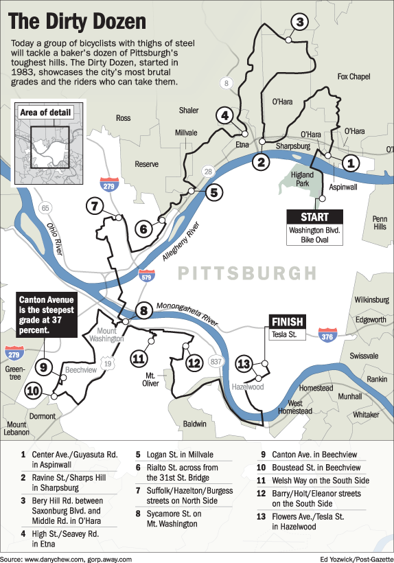
Canton Ave is kind of a bear to get to, especially if you don't know your way around. I would highly recommend Sycamore (#8 on DD route), though. Easy to get to, and gets you to an amazing view of town.
http://www.dannychew.com/PG%20DD%20Map.gif
edmonds59
2016-06-28 12:12:35
My route home involves the reverse of what I suggested earlier: Going straight up Federal or Perrysville, past Riverview Park. Federal is just a bear, something like a 14% grade in places. Perrysville peels off of Federal about 1/3 of the way up, and is only about a 7% grade.
For added fun, go up the side of Allegheny General Hospital on James Street, and climb the 160-ish steps into Fineview. That only gets you about halfway up the hill. The rest is a jamble of turns and potholes and belgian block, eventually getting you to Federal and Lafayette, very nearly the top of the hill.
If you particularly like steps, go over North Ave to Howard Street, just short of I-279, go to the almost-end, and start up Rising Main Avenue. About 370 steps to that staircase. That's the easy part. The paved, car-traversable bit of Rising Main is too hard for me to pedal, so I usually walk up the rest.
There are a lot of things to explore on the North Side.
On the level section, take a few minutes to wiggle over to Arch Street and check out Randyland.
stuinmccandless
2016-06-28 13:30:16
We may be able to drum up a few people to ride with you if you are considering after work 5 PM ish. Feel free to PM me if that is of interest to you.
durishange
2016-06-29 13:02:58
Guy just asks for a route suggestion and you guys form a welcome to Pittsburgh committee? What's wrong with you, trying to win a nice guys award? Whatever happened to suspicion of outsiders?
jonawebb
2016-06-29 13:09:55
I'm THAT guy who says, "hi" to everyone who passes me on the trail. :-)
Besides, everyone has their favorite routes. Riding w/ locals gives a better shot of changing the route on the fly.
durishange
2016-06-29 13:31:09
Recently RBR Pittsburgh had a rally and there was a city route. Here is the GPS for that. Almost entirely paved trails. Happy riding! :)
https://ridewithgps.com/routes/14324402
sarah_q
2016-06-30 08:20:33