BIKEPGH MESSAGE BOARD ARCHIVE

« Back to Archive
33

the worst suburban road for cycling?

I just posted this in another thread, but the topic deserves its own:


Next to US19 through Wexford Flats, the worst suburban road I can think of for cycling in Allegheny County is Steubenville Pike.


Any others? What *really* sucks? Frankly, I don't think McKnight is that bad. Lots of traffic, but wide shoulders through much of it.


Steubenville, and Perry in Wexford by North Allegheny High School, are absolutely horrendous.


stuinmccandless
2009-08-04 00:03:52

Really? I ride on the Steubenville Pike all the time now, whereas when I lived in the N. Hills I was honestly scared of riding on a lot of the roads and it definitely contributed to my getting out of biking.


As long as cars have a chance to see me before they run me over it doesn't bug me. Where I lived (off Sloop), ugh... too many cars barreling around blind corners covered with trees and minimal shoulder. Sloop itself is not great, that section of Rochester going up the hill I would not even consider, even Highland is kind of dicey. So I felt essentially trapped there :)


salty
2009-08-04 00:59:04

+1 for 19 through Wexford. That's the only place I ever got tagged by a car, although it was a bit past the really crappy section in the mega-shopping-conglomerate section.


Business 22 in Monroeville is unlovely to the nth degree as well.


reddan
2009-08-04 01:07:59

Tough competition. Has to be a road where cyclists try to ride on it once in a while at least. So I nominate Lebanon-Church Rd (or Curry Hollow Rd, whichever you call it). Is that suburban?


nfranzen
2009-08-04 02:43:32

I as just going to say business 22.


My SR50R tops out around 57mph, but sometimes I feel like I am going dangerously slow on the stretch from Penn Center going down to 376/Penn Hills.


There is no shoulder, and I would say the average speed when there isn't traffic, is over 65mph. Plus, without a divider, some people in the left lane tend to drift out of their lane. I would never ride on this road. Getting around it isn't too bad.


ndromb
2009-08-04 04:00:13

C'mon, US Route 30 (ardmore blvd) from WTAE all the way to Irwin.


willie-p
2009-08-04 13:35:09

+1 for ardmore blvd.


mntbiker25
2009-08-04 15:19:37

I revoke my earlier post - WTAe all the way to St. Vincent College!!


willie-p
2009-08-04 19:29:06

+1 for US30. Ugh.


scott
2009-08-05 12:12:48

The worst I have ridden a few times is 837 in duquesne.


igo
2009-08-05 12:20:45

Route 65 from Emsworth to Sewickley. Or even beyond, to Ambridge. Fast and with no shoulder to speak of. Cycling to and from Sewickley would increase dramatically if there were an alternate route (other than 51 or Mt. Nebo Road) or if the 2 miles between Emsworth and Sewickley had a useful shoulder.


swalfoort
2009-08-05 15:15:48

Seeing the Ardmore/US30 comments make me sad, my wife and I have been looking at some houses out that way.


rsprake
2009-08-05 15:36:21

I have ridden the bit of PA48 between Northern Pike and WmPennHwy. Again, huge amount of fast traffic and no shoulders. What scared the bejesus out of me, though, was trying to stay on that road instead of getting on the Parkway East inbound. The majority of cars are headed for the ramp, and if in daylight, may be temporarily blinded while under the overhead roadway and, so, not see you.


stuinmccandless
2009-08-06 02:27:10

SOUTH HILLS GUYS!

"saw mill run blvd" 35 mph road that is ok to do 70

on.

route 88 state road no shoulders.

lebanon church road.


steevo
2009-08-06 13:43:42

During the first running of Crush the Commonwealth a group of guys from Philly decided to disregard the official route and rode Route 30 from Philly to Pittsburgh. Not my idea of fun. At all.


eric
2009-08-06 13:59:24

Short & unsweet: Three Degree Road in Ross Twp, uphill section between Babcock and Perry Hwy.


This quarter-mile stretch has several things going at once: High traffic volume, a fairly steep grade, absolutely no shoulder just a tall curb, a gradual right curve, fairly high traffic speeds (or a dead standstill 20+ cars long), and tall grass in summertime that blocks driver visibility. You cannot even walk the bike along here, if traffic is stopped.


There is no safe way to travel this road on a bicycle, going this direction.


stuinmccandless
2009-08-08 18:40:00

You forgot to mention the sheet of ice that forms in the winter due to car wash drippings. Good one in any case!


salty
2009-08-08 19:35:47

I thought I'd top this thread, based on my experience with OUTBOUND McKnight Road this afternoon. INBOUND really is not too bad; I've done it a bunch of times. Outbound, however, truly sucks. No, beyond that, it's just plain dangerous.


On my Flickr page I've shown six photos:

Photo 1-Where East/Evergreen/McKnight merges with the HOV Lane exit ramp and the I-279 McKnight Road exit ramp, there really is nowhere for a cyclist to go. About the only option is to wait for traffic to clear from the two exit ramps and then dash to the far shoulder.


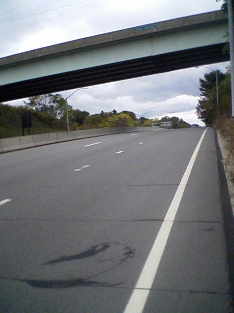
Photo 2-Once on the far shoulder, the shoulder itself almost disappears by the top of the hill. What little space exists the cyclist has to share with overhanging burdock barbs at face level.


Photo 3-Down the next hill, up the next and down the one after that (all of which time you're dealing with SNAP grooves carved into the paved shoulder), you approach the southern Babcock Boulevard interchange. McKnight crosses Babcock on a narrow bridge. There is absolutely nowhere for a cyclist to go. A sidewalk exists, but you have to dismount and carry the bike over the guardrail.


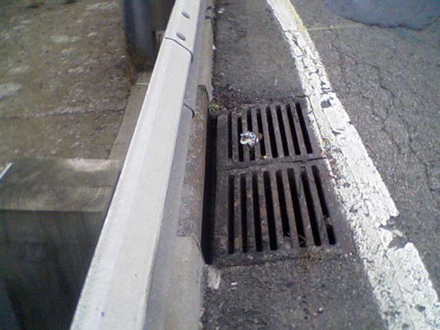
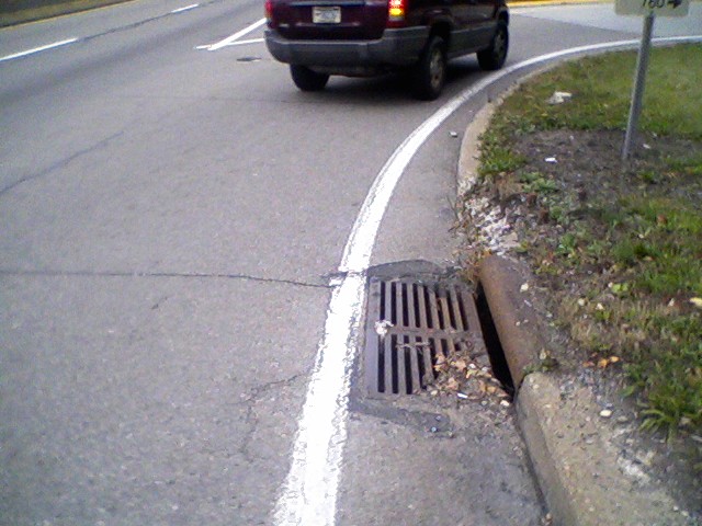
Photo 4-If you chose the street (brave you, but foolish you), a drain grate awaits you at the end of the bridge, one of those with longitudinal slots that could eat a narrow road tire. My moderate width tire was OK, but the slots are wide enough that they would have argued with me over possession of my tire, even if not wide enough to swallow it whole.


Photo 5-Assuming you missed the one, there is a second one a few yards later.


Photo 6-From the Babcock merge lane north, it ain't pretty at all. There is no shoulder at all, and what little cement drainage area exists is filled with broken glass, loose gravel, and, as is visible in this photo, occasionally missing completely because of a tiny landslide. Note the dirt pile adjacent to the telephone pole just after the hydrant. This is just past Red Lobster.


I took the lane of outbound McKnight, all the way from Red Lobster to Peebles Road, at 4pm on a Wednesday afternoon. My presence there did not please a lot of people. Too flippin' bad.


Oh, and the whole thing is uphill that way, too.


stuinmccandless
2009-10-07 21:42:50

Good god, Stu! Glad you're ok.


scott
2009-10-07 22:51:28

I'm fine, thank you. At the time, I'd just climbed Rialto maybe 30 minutes before, so was feeling pretty good.


I did this to prove the point: These roads are just plain deadly. I knew what I was getting into, but wanted to document it. Imagine someone unknowingly happening upon those spots! I did this in broad daylight. Add darkness, rain, DUI, whatever. This road, and others like it (see posts above) simply should not be ridden by cyclists.


What I didn't say in the post was the near-wreck that occurred at the HOV/279 merge point while I was taking my 2nd photo. Sight lines here are just about ideal for all three traffic streams, but someone coming off 279 felt it necessary to swing way left to avoid me (parked) on the side, and nearly smooshed another car in the left lane.


Short of $10 gasoline or a complete rebuild of these roads, I really don't know what can be done to resolve it, either. Ideas, anyone?


stuinmccandless
2009-10-08 02:19:17

Stu, Those pictures made me cringe. Those roads were never designed with bikes in mind at all.


igo
2009-10-08 03:22:00

Short of $10 gasoline or a complete rebuild of these roads, I really don't know what can be done to resolve it, either. Ideas, anyone?


The end of suburbs? Suburban America was designed around the car. $10/gallon gasoline would also happen before the county redesigned the suburban arteries.


bjanaszek
2009-10-08 10:58:09

Stu, you really know how to have fun!


I'm thinking that when gas goes from low-priced to medium-priced (i.e to $10), rents and real estate in the bike friendly city areas might go way up.


I guessing gas won't stay medium-priced for long.


I don't know how much it costs to get gas-equivalents from renewables, without government subsidies or tax breaks. I expect that will be the price of gas within the lifetimes of most of us.


Mick


mick
2009-10-08 15:41:32

I was gonna say 837, but Stu's route is worse.


jz
2009-10-08 16:33:33

For sake of safety, I'll offer some alternatives for those headed north. If you're going out East Street, use the sidewalk; note that you have to cross East at the light just before the I-279 bridge to stay on the sidewalk.


1) When you get to the East/Evergreen split (by Venture St on-ramp), get left and go up East to Perrysville.


2) If you do stay going straight (it becomes Evergreen at that point), turn right under 279 onto Evergreen.


3) If you still persist in going straight (that's where going straight becomes McKnight), and deal with the Photo #1 and #2 spots, crest that hill, descend to the traffic light past the gas station, then wiggle rightleft downhill, which takes you down to Babcock, where a left takes you north.


Of course, if you're headed out of the city, I highly recommend the river trail to Millvale then Grant-North-Babcock.


More on the outbound McKnight discussion: What makes outbound so much worse than inbound is its being uphill, plus four right-lane peel-offs I did not previously mention: Two at Ross Park Mall, one at McIntyre Road, and one at Peebles Road. All force the northbound cyclist into the second-from-curb lane. Inbound has only two, one (for southern Babcock interchange) on a downhill so you can have some speed, the other by the I-279/HOV peel-off, which is only one lane wide and at the top of a hill so traffic is usually slower.


Also, that outbound downhill just before the southern Babcock intersection (Photo 3) has traffic speeds upwards of 70mph. By the northern Babcock intersection, it seems to be a lot saner. I was able to do a triple left lane change to make the left onto Perrymont with surprisingly little trouble, in heavy rush hour traffic.


stuinmccandless
2009-10-09 14:02:33

Route 28


adam
2009-10-15 17:56:29

I think about the Homestead Grays Bridge, my McKnight Rd experience last week, and some of the other roads mentioned, and wonder, Just What If:


Just What If we were to form a Critical Mass type of ride along one of these roads? I felt pretty ballsy, taking a full lane of McKnight for three miles, but I would've felt a lot safer if I'd had a lot of company. Take Two on the idea is to ride 20+ of us, single-file, taking the lane, forming a chain a quarter-mile long.


"As far to the right as practicable", to me, means staying LEFT in the lane if I fear for my safety being squeezed into a curb and broken glass, and blown past at 40mph every 10 seconds.


Probably this idea needs its own thread.


stuinmccandless
2009-10-15 23:43:42
Topping this ancient thread because, for the first time in a long time, I tried McKnight Road *outbound*. Note that I try *inbound* probably once a week. Almost never have a problem. Today, this happened.
stuinmccandless
2013-03-31 16:12:05
The Homestead Grays Bridge is not all that bad. Going down you should wait at the Old Brownsville light (or lower) until just when the light goes red. Then you pedal like crazy down the bridge. In my experience, the cars usually catch up with you at about the city line (mid-river). Since you have the lane (and the sight line is optimal) they know enough to already be over in the left lane. The slow ones seem to be doing at least 40mph. It more-or-less goes with the 25mph speed limit signs, I guess. Going uphill, the right-hand sidewalk works great; you might not even have to gear down. This is after the bridge intersection, which you can get to on either sidewalk or road. You run into people but there's enough room for everyone. Though I did once see a roadie go up the right lane. And a tandem at another time. Good for them, but I don't mind leaving the uphill stretch to the cars.
ahlir
2013-03-31 20:25:51
I read most of this thread before I saw that most of the posts were from 2009. Pretty much all of the information is still current. :(
sew
2013-04-01 06:44:08
The McKnight Rd bridge over Babcock (Photo 3, above) has been rebuilt. I haven't been across it on a bike, but it seems wider when I drive over it. I'll check it out sometime and report back. Still and all, outbound McKnight sucks, the whole length. Inbound is busy but do-able. I don't know why there should be that much of a difference.
stuinmccandless
2013-04-01 07:51:37
Ardmore Blvd is still pretty terrible (I take it for about a mile rather than going up the hill to Brinton Road or Greensburg Pike when I'm feeling lazy-and-brave ). I wish there was something that Forest Hills or North Versailles (and other municipalities further east) could do to calm it down, but it's a state road and the boroughs have very little influence over it.
jamesk
2013-04-01 10:01:10
My worst is West Carson Street, especially the narrow tunnels under the overpass to the West End Bridge. I would not want to riding there when a bus comes through. And the road west of there is a close second: narrow lanes with crappy road surface, heavy truck traffic, and a jersey barrier wall on the right. I used to ride Ardmore but there are reasonable if hilly alternatives like Avenue A. But there's no good way around West Carson Street.
jonawebb
2013-04-01 12:04:28