There's a reason why the rich people and the dead take the hilltops.
2011-03-13 13:35:29
This isn't your grandfather's flood. Modernized for today's fast-paced lifestyle.
OK, I took some pictures riding around yeaterday. 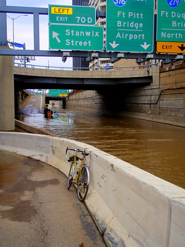
There's a reason why the rich people and the dead take the hilltops.
Except in Pittsburgh: Troy Hill, Hill District, Fineview, Perry Hilltop, upper Millvale... etc. (Although many of these have cemeteries, very few rich people live there. Pittsburgh's kind of upside-down that way, compared to other cities with similar geography.
ALMKLM - The outer parts of Pittsburgh are more representative: Homestead and Pitcairn, as two examples, the poor grunts lived in the flats and the rich took the hilltops.
In Homestead, the library seems to be about the dividing line. Below it, cheap housing. Above it, must've cost a couple more pennies to construct.
Some day, though Stu, somebody is going to build high-end homes, condos, whatever, on places like Troy Hill and the other hill tops with great views - just like you're seeing on Grandview.
I'm not saying its good or bad, by the way... but there is a certain inevitability that follows wealth. (IMHO.)
I think one of the reasons the rich didn't populate the hillsides in Pittsburgh was due to the amount of soot and smoke that hovered over the city and its hills for years.
i took some pics while out today on the north shore, and a few overlooking the point from the bridge. sorry, they're pictures from my phone. forgot my camera (and it was overcast)


 (the fountain is in the middle)

Well at least the guys who hose off the sidewalks will have work
Big flood for sure, but not quite as crazy as when Katrina (I think it was Katrina...) came through here. There were giant boats up in the stage area of Point State Park.
I was out of town for several days when that hit the burgh and actually i lived in beaver county at the time so I didn't see any of that in person.
That year was especially bad. Cool photos!
I believe that was Ivan that flooded the area- hit land around New Orleans, then came up the Mississippi and Ohio valleys.
I remember riding home and wading in water over my knees next to Panther Hollow Lake.
The boats up on the lawn at the point was quite a sight.
Ivan was Sept 2004, and did unbelievable damage to Carnegie, Etna, & several other towns in the area. Katrina was late August 2005, and gave the area a good dousing, but not devastation like a year earlier.
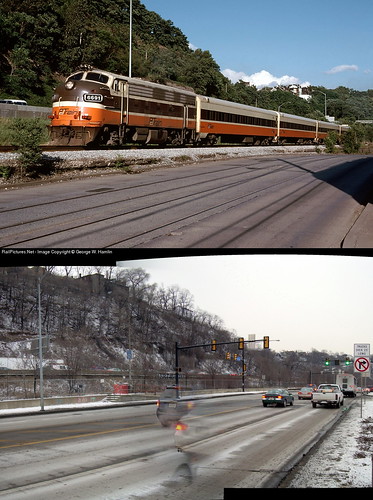
Does anyone remember the big flood in Downtown Pittsburgh just before Katrina? A 36-inch water main burst on Fort Duquesne Blvd right outside KDKA's studios and flooded all of Gateway Center and the nearby Stanwix Street area.
I was on River Street today. There was a stretch, around the parkway bridge, that looked like it had flooded at some point (lots of debris). But is was all dried out when I went through; maybe it was rain wash? In any case the river looked really high...
Yeah, River Road was pretty cool - you could see the debris from where the river had extended at its high point. And being so close to it at such a height was impressive.
@stu I was working in the Westinghouse building at the time and my desk looked out over gateway center (facing north) it was pretty impressive and a bit hilarious.
My memory of Ivan was riding through hub-deep water along Butler Street due to all the drainage from the hill. Very crazy.
After Ivan, water on Ninth Street downtown north of Penn was high enough to flood the street but not quite high enough to cover the sidewalks. There were waves running slowly southbound down the street, and you could walk side by side with them, just out reach of the water.
Ivan was 7 to 9 inches of rain in about 7 hours. A quarter inch is enough to cause raw sewer discharges, a single inch total is enough to get a couple of low areas wet. Ivan came hot on the heels of Charley and Frances, which got everything soaking wet already. The perfect storm.
Yup, Ivan is what I was thinking about. I remember seeing cars floating around in Etna on my drive home and onto Rt 28 from Rt 8. Subsequent weeks had bulldozers moving piles of debris and garbage around. Nuts.
any word on river rd today? still good to go that way?
Pictures from Saturday (3/12)
At the 9th St Bridge

Under the 7th St Bridge
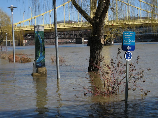
Flotsam piled up near the Vietnam Veterans Memorial, Northside, viewed from the Duquesne Bridge. The flooded fountain at the Point is visible in the distance.

it's things like this that make me question the valitidy of attempting to seed bomb or guerilla garden the jail trail. between the salt and the flooding, what would grow?
But the jail trail wasn't flooded this time, was it? I think it's 15 feet or so higher than the bits that flooded.
The jail trail area may well have flooded in 1936, but we've built lots of dams since then.
hunh, good to know. I guess I just assumed when the mon wharf is flooded, the jail trail is too.
The jail trail stands a good 15 or maybe 20 feet above the Mon Wharf and was not flooded. I'm not sure whether the rail line that used to run along that corridor was flooded in 1936 but on the map I found it looks like it was a near thing.
I think the pool level of the rivers are 20 feet. Get a few feet above that and the Mon Wharf floods. A little more and the 10th Street Bypass is flooded. It takes 25 feet to overtop the Mon Wharf wall and flood the bathtub.
The St. Patrick's Day flood of 1936 was 46 feet.
Plus in 1936 the called it Ye Olde Jaile Traile.
The corridor was active rail until 1989.