So, my summer commute route includes one block of Fifth Avenue, by Ellis School in Shadyside. I've been trying to train the drivers to expect cyclists there, but after two road rage-y (on my part - but they were passing poorly) commutes in a row I thought I'd try the supposed back way through the park to connect to Ellsworth.
Well, it totally didn't work because the trail is closed along the new Bakery Square building site (not even a sidewalk exists, so I had to hit the walk signal and go out onto Penn, which was also all construction-y but with surprisingly zero car traffic so I just rode to Ellsworth from there).
Is there a way through there? It looked like that new red road might connect through to the crummy trail, but I wasn't sure and didn't want to backtrack a second time after trying the parking lot.
Is the crummy trail open? I couldn't tell, there were a lot of traffic cones there and I decided not to try it.
My winter commute route involves Hamilton Ave. and Broad St., so I avoid this area entirely. The "summer" route goes through Frick Park when the trails aren't icy or muddy, and I end up on Reynolds, which is how I got to Mellon Park.
erink
2014-11-24 11:14:20
You can get through there but I'm not sure if I can explain it since I've only done it once myself (going the other direction). You were on the right track going through the parking lot behind the apartment building, then you can make a left onto the new trail that I think is what you're calling the red road. It doesn't connect to the "crummy trail" directly (assuming you mean the trail wedged between the black Village of Shadyside fence and the construction fence), but it does come out either on Marchand or Social. You do have to go through the dirt to get around the fence.
WalCap told our facilities dept. the trail was "open" a week or so ago, which is what prompted me to check it out. I asked why there was still a fence if it was "open" but I didn't get an answer.
salty
2014-11-24 21:09:29
Thanks! Yeah it looks like the trail between Village of Shadyside and the construction might be open. But the section of trail that runs along Penn is definitely not open.
The red road looks like a driveway in front of the one building. It's sort of parallel to Penn. I might go exploring there next time.
Google actually says you can cut through Ellis's driveway, but I'm pretty sure they shut the gate at Kentucky after drop-off. I don't usually come through until after 9. (At least I'm an alumna so they might not mind!)
Coming home tonight I took Shady up to Pittsburgh Center for the Arts and cut through the park there. It wasn't bad in that direction, but it's a bit of a climb and I don't have a shower at the office.... :)
erink
2014-11-24 22:54:33
Yeah, the trail on Penn is definitely closed, which sucks, I used it every day and now I get to ride on Penn or through the BkSq lot instead.
The road I was talking about is perpendicular to Penn, parallel to the VoS trail.
I was just talking to a coworker yesterday about Ellis, actually - she said she got yelled at twice by a security guard while trying to walk through there so she doesn't do it anymore.
salty
2014-11-25 10:04:36
Looking forward to the future of pittsburgh when we can access all these trails!
1) Strip district Trail (closed for buncher company construction)
2) Hazelwood Trail (closed for almano site construction)
3) Poccuset St Trail (closed for greenfield bridge construction Beginning December 2015)
4) Bike connections through Bakery square 2.0 site (closed for construction).
*just a bit of sarcasm. much of this is really going to lead to better infrastructure.
benzo
2014-11-25 14:09:04
re BSq2: it's annoying. I recently checked out the bit where the NW Passage™ used to be; it was a dirt mountain.
My current solution is Beechwood->park-> BSq1->ELB->Station/Broad->Highland. It works.
If you're in a hurry, Beechwood->5th->Shady. But the speeding cars will catch up with you (i.e. 5th Ave speed limits are never, ever, enforced).
ahlir
2014-11-25 21:15:54
I rode through BK 2.0 last night. Putnam st is open. It's a little confusing to zig zag through the site. You can take the connector road from putnam st to the bike-ped connection in the center which connects you to social way.
The west side of the site is fenced off, but nothing was blocking access to the central bike-ped trail last night. There is a short section of unpaved path you need to cross right as the central path starts.
You should be able to access this from the bike trail to beechwood blvd in mellon park from what I could see. You might have to dismount, but I think the fencing is mostly gone from the east side of the site.

benzo
2014-11-26 10:17:02
I found it! I took the red road (it is literally red). Don't go all the way to the end - there's a left to a nicely landscaped asphalt path with emergency buttons and everything. The path comes out near Festival St. and I found my way to Howe no problem.
There was a 4' x 4' loose asphalt section joining the red road and the path - I'm not sure I'd ride over that on skinny tires because it would leave a mark (I actually walked it to avoid getting any trouble from the workers there). I'm sure it will get finished soon.
I believe you also can ride through the parking lot to get there, and that looked to be continuously paved.
I was a little intimidated to ride the red road because there were workers working there, but they didn't say anything or look at me funny.
erink
2014-12-09 15:42:27
On my way home I've started rolling up Shady and through Mellon Park to Beechwood. The climb the other direction is a little intense for four blocks from my office and no shower when I get there.
erink
2014-12-09 18:06:49
i rode this for the first time the other day, it's great. coming from beechwood, you can go thru mellon park parking lot, make a left and it will take you right to the red road where theres the nice, well lit bike path. rode it last night again around 9:30, there's no fence
Don't feel intimidated on the Red Road, the building is open to the public now. Google is actually up to date on this:
http://goo.gl/i4iQmg
Anyway, from/to Beechwood is basically like this:

erok
2014-12-10 21:30:19
Traveled the new route a couple of times, in both directions. I'm going to miss Broad and the ELB... A couple of niggles (from a commuter):
1) The paving work isn't all done and there's a couple of stretches with uncompacted stone or dirt (ie, plan to speed up and hold on to your handlebars). This morning there were workers around, so this ought to change pretty soon. It would have been better if they had planned for a curb cut at the point where the path reaches the street; as it is people and bikes have to mix on what's essentially a ped path.
2) The path skirting the west side of the playing field is a mess (once, a trench was cut to deal with something underneath but never patched). Not so much right now, but during the summer when there's a lot of people around it's difficult to navigate. I would suggest getting in the habit of biking along the western edge; much wider and fewer people.
3) The alley at the Shadyside end is also a mess; it should get repaved.
ahlir
2014-12-15 19:05:16
It looks mostly finished now. I just discovered it the other day, and was wondering if anyone else knew about it.

I used to go through the Wiggle aka NW passage at 40.455139, -79.918289 when the school was still there as a nice break from the traffic on Shady and Fifth. Since the school was removed; however, I've been forced back into the crazy traffic to get to Shadyside, Oakland, Bloomfield or Lawrenceville - and I've had some near misses, hoping that my mom doesn't get another call, "your daughter is here in the ER". I'm SO glad there is another option now, albeit a hidden and twisty one.
The end of the paved trail that goes around the baseball diamond and connects to Putnam Street seems really dangerous. There's broken pavement, some gravel and rutted mud. The routing also lacks connectivity to the parking lot path: you can go across the grass and over the steep curbs that parallel Putnam. Or, go all the way to the bottom of the rutted trail, perhaps teeter precariously on the awkward angled entrance to the sidewalk and then ramp down the sidewalk to get to the Red Road or head back to the top of the hill and back down again to the parking lot path which eventually leads to the well-lit bike/ped path. I always ask myself - what would someone in a wheelchair want in this situation?
If the City ever decides to repave the path around Mellon Park's baseball diamond, I could see putting a fork in the path to enter Putnam where the upper parking lot is, and the other side continuing adjacent to the sidewalk (not actually on it) and connecting to the Penn Ave trail. Which, btw, I wish would continue all the way through to Penn Circle/Centre Ave.
velomuse
2014-12-19 11:31:56
This has been part of my commute for 4 years; I used to take the weird split path (which has been like that for as long as i have been riding there) in the AM and the other one in the PM for no particular reason, but now I always take the latter for the reasons above. Hopefully they fix that connection though, it is useful. OTOH at least the cars that liked to park on or blocking the path haven't returned yet.
I do think Walnut Capital is generally pro-bike/ped, and they have dome some good things like putting in the path on the west side - which has been invaluable. However, they or their contractors (I've also heard the URA implicated) have also done some insanely dangerous things on that site whixh took weeks or months to resolve, or are still unresolved. One morning I rode that path down to Putnam only to be nearly decapitated by an extension cord that was stretched across a gap in the fence. It was wire-tied on both sides so it seriously could have been fatal. I have complained about the conditions there until blue in the face so it is nice to have some backup.
salty
2014-12-20 02:19:02
Yeah, the new path they put in is really nice. I agree that it's a big letdown when you get out onto the road, which is a muddy crumbly mess! But not dangerous (watch out for ice).
I'm not sure where the nasty spots are on the path around the baseball diamond - as far as I can tell, it's all cement paved and fine there until the end. There's one unfinished spot at the end where it connects to Putnam, you have a choice of 3' of mud or 2' of large gravel (rail bed type stuff) and then a curb drop. I usually waddle through the rocks.
I am following almost the exact route that Erok mapped, but instead of taking the red road I go left on Putnam and ride through the parking lot. That road that looks like a spur on Google Maps actually has a paved trail connection that runs in front of the parking space blocks on the Penn Ave. side. This avoids the soft asphalt section between the red road and the trail (if that's even still there).
I've seen the same guy walking his dog there twice, so at least a few of us are using it!
I haven't tried this at night, glad that it's lit and plausible. I've been rolling up the hill on Shady and through the Pittsburgh Center for the Arts parking lot and down to Beechwood (talk about dark!), but this is probably easier.
I've always said I don't need bike-only trails, and I was fine riding on roads, but I have to admit that this has made my commute a lot more pleasant. Way more relaxed. My one-block stretch of Fifth wasn't that bad in the summer, but in the winter I think people are worse about being nice to cyclists and it was making me dread getting on the bike.
I still dream of civilizing those drivers by riding there, but maybe I'll wait for summer to try again.
erink
2014-12-21 12:24:10
Here's a map of the logical future bike routes from Beechwood & 5th Ave to Bakery Square (green curve) and to Shadyside (red curve).

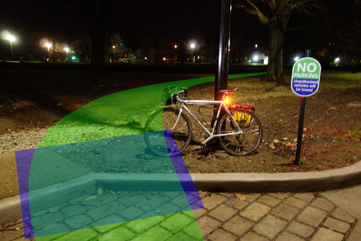
The new curb just constructed at point E is ridiculous and unacceptable. There is no ramp from Mellon Park's path to Putnam St! This needs to be fixed. Below is a photo of that curb (at E looking toward A), with recommended changes overlayed (ramp in blue).
Also, a path with ramp needs to be built from points A to B on the map, so that route ABCD is bikeable. ABCD is approximately the same as the old bike/ped route that has existed for the past 5-10 years. Currently, there's a curb at B that makes this path unworkable. The alternative, AEFGCD, that Erok mapped out, is much longer.
paulheckbert
2014-12-24 19:19:24
Two years later, my wish came true! In late 2014, I spoke of the need for a bike lane to Putnam St (now called Bakery Square Blvd) to help cyclists get from Beechwood Blvd and Mellon Park to Shadyside. That little connecting path appeared a few months ago. Yay! In the photo below, we're standing at B, seeing E on the left and A on the right (see map from 2014/12/24 above).
https://flic.kr/p/PNawBA
paulheckbert
2017-01-09 12:54:14
The Bakery Sq bike/ped improvements are great! Including a bike track from the "boulevard" to ELB.
Also note that the B<->C is now complete: you don't have to wiggle into the parking lot.
Those bollards at B are unfortunately a bit too close together to just ride through at speed (ok, for us klutzes). Not sure just how ADA it is either. I tend to use the cut at E-F instead.
Now, if they'd only repave the bit from the parking lot to Penn, everything would be super. (The stretch from B to the lot is great but at least in the past, during games, people set up lawn chairs and little kids wander around; it's safer to go along Penn.)
ahlir
2017-01-09 13:23:32
Yeah, those bollards have a NARROW gap. My big wide mountain bike bars make me slow to almost a stop to navigate it when I'm riding this way to frick.
benzo
2017-01-10 09:28:02
Nice! I haven't been commuting recently but that will be a nice improvement.
erink
2017-01-10 13:22:26