This Saturday, I'd like to bike to Rankin from Friendship to do the tour of the Carrie Furnaces. Google Maps wants to take me through or around Frick Park to get there, but I think a better and safer ride might be to cross the Mon and get onto the 3 rivers heritage trail/GAP and take it down to the Rankin Bridge. I don't mind adding more distance to the ride if I can spend more time on a trail and less time on the road.
However, is the Rankin Bridge safe to ride across? I looked at the BikePGH map and the bridge is identified as one of those 'danger' routes, but says the sidewalk is bikeable. Can someone comment on this? Seems like I always hear on the news something awful happening on the Rankin Bridge.
Finally, while I'm in the area of Rankin, is there anything else worth doing or seeing either in Rankin or in the nearby neighborhoods? I don't get to that part of the city much, so I'd like to explore a little bit. Things off the beaten path encouraged! Thanks.
cal34
2013-09-25 15:17:07
I don't know anything about Rankin, but
The Braddock Carnegie Library is a wonderful building
Braddock Community Cafe for a bite to eat (check hours of operation).
Braddock farms is pretty cool
Go see Joe Magarak at the entrance to Edgar Thompson steel (oh man I think I need to grab a tag).
Also somewhere over there is a thing called a Konbit shelter, an earth shelter, that I've always kind of wanted to track down.
edmonds59
2013-09-25 15:55:29
Rankin bridge isn't hard to cross. We like going that way to get to Braddock. We use the sidewalk going north and the road on the return. The sidewalk is comfortably wide, and except for no curb cut to get down onto the road on the other side it's a good way to go. Southbound there's a nice, wide berm on the bridge and I prefer to use that.
Be careful on the road getting back to the trail - there are a couple of those tire-grabbing, longitudinal, drain grates on that road.
@Edmonds58 - the Konbit shelter is in North Braddock on Jones St (across from the Transformazium).
http://pghmurals.com/Super-Adobe-289.cfm
srpit
2013-09-25 18:03:05
If you have any trepidation, and don't mind a few extra miles, consider going via Oakland/Schenley to Second Avenue to South Side trail, then heading east along the GAP. You can see the eagles (maybe), stop at Waterfront (or Blue Dust) for a bite to eat, then continue east. The ramp to Rankin Bridge is not great, but it is wide. Then take the sidewalk across to Carrie Furnace site.
swalfoort
2013-09-25 18:12:57
cal34 wrote:Finally, while I’m in the area of Rankin, is there anything else worth doing or seeing either in Rankin or in the nearby neighborhoods?
As the others have said, I think Braddock is very interesting and underexplored, and so is adjacent North Braddock:
http://pghmurals.com/Braddock-PA-murals-public-art.cfm
http://pghmurals.com/North-Braddock-PA-murals-public-art.cfm
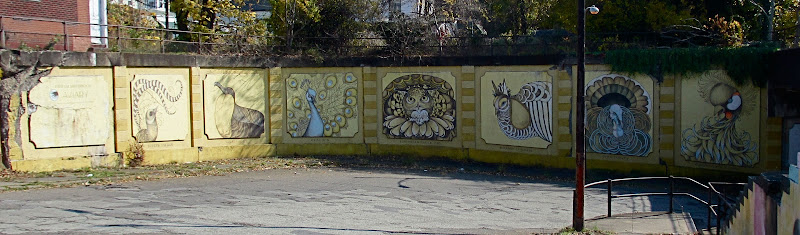
I had to pick just one thing to see, it would be the
"North Braddock Aviary and Hall of Male Birds In Courtship Plumage". I mean, you couldn't make this up. And I would definitely want to eat at the BRaddock Community Cafe it it's open.
http://pghmurals.com/North-Braddock-Aviary-Hall-of-287.cfm
vannever
2013-09-25 18:33:42
vannever
2013-09-25 18:39:16
You'll have to do roads in any case.
Try ELB->Hamilton-> Trenton->W.Hutchinson->Braddock->Kenmawr.
It's a bit stop-and go-on some of the side streets but there's little traffic, to make up for it.
Yes, the Swissvale->Rankin bit might seem daunting. but it's really not that bad: there's stop signs so speeds don't get out of control. Just be sure to get on Kenmawr else you end up on a highway-ish bit connecting to the bridge, (Though it's ok on a Sunday morning.)
If you switch to Monongahela in Braddock it'll be a calmer ride.
If you go the South Side route be aware that the approach to the Rankin bridge is a bit daunting. Steely determination goes a long way.
Rankin has some old churches, but Braddock has a bit more character.
ahlir
2013-09-25 20:35:58
Google Maps shows the Duck Hollow trail extending east all the way to (and past) Carrie Furnace. Does it really?
If so, one could ride to Homestead, take the High-Level Bridge (sidewalk) up to Old Browns Hill or whatever they're calling it these days, and then come down to the trail. Might be a little less hair-raising than the approach up 837 to the Rankin Bridge.
epanastrophe
2013-09-26 11:34:06
Did they put that up again? I thought I'd gotten them to delete it. It's really not there. There's a dirt trail part of the way, and then around the Carrie Furnace there's a gravel road. It would probably be fun on a mountain bike. But not recommended for a road bike.
jonawebb
2013-09-26 11:52:25
I've gone up Commercial and through Swissvale a few times. It's low key with little traffic as there is really no reason for much through traffic in the area.
Just make your way down to the Irish center any way you like (Beechwood->Forward or through Frick Park are rather stress free) and then work your way around. It's not terribly direct but usually figure that if I'm in a hurry, I ought to just drive.
Both sides of the Rankin bridge have massive shoulders - whether they are free of debris can be a toss-up. Also, the speed limit on the Rankin bridge is only 25 so it's not a big deal. ------ Just kidding on that last bit about the speed limit. It really is 25 but people drive around 45-50 there.
andyc
2013-09-26 11:56:25
I live in Regent Square, and my normal way to get there from Friendship is Penn Ave-> S Braddock. You can actually take S Braddock all the way to Braddock, but near the Parkway and once you pass under it, drivers become especially moronic.
To avoid most of that, after the underpass, go right onto Monongahela Ave and follow it until it becomes Miller St. Then you can go right at Harriet which will become Rankin Blvd. That should get you in the right area.
The ride along Mon Ave is usually pretty tame, with wide streets and not much motorized traffic.
jaysherman5000
2013-09-26 12:27:28
There is also the little-known and less-used paved trail alongside the East Busway from South Ave in Wilkinsburg to the Swissvale-Rankin line ... with the notable exception of the section through Edgewood. Someone should go out that way with a GPS sometime and map that out. (I don't have the equipment and it's not exactly next door to me.)
stuinmccandless
2013-09-26 13:32:28
I regularly take the Frick Park way. Go over to Hamilton and Homewood Ave (by Freeride/EEFC), then head south by Irish Center, then to Duck Hollow, then take rugged trail to Carrie Furnace. That's pretty much all trail and I'd take the East Liberty Bike Lane to get over (to a certain extent) Frick Park
sgtjonson
2013-09-27 13:12:02
I like JaySherman5000's approach, it's an ok ride. The Rankin bridge itself isn't too bad, it's just the crazy traffic on either end that scares me.
headloss
2013-09-27 13:20:37
I go over the bridge about ten times a week; haven't had a problem.
A potential trick for going from the Waterfront side (from the Waterfront) to the Rankin side is to merge in the left turn lane way early, like almost before you start going uphill. There's a striped road section you can kind of ride in. It's hard to cut across from the right by the light.
Also, if you're in the left turn lane and have a green, the opposing traffic has a red light, so cars that are turning right on the bridge should be waiting until the intersection is clear before proceeding as they normally would on a turn-on-red situation. I.E. you have right of way, but keep an eye out.
P.S. I ride in the shoulders, they seem to be wide enough. I regularly pass pedestrians going the opposite direction on the sidewalk, which would be annoying to navigate if I were on it.
sgtjonson
2013-09-27 17:08:42
It's a fairly direct route to go to Frick Park at Reynolds street and down to duck hollow. Slightly longer on the roads than going to the Panther hoolow trail (2.8 miles vs 2.2).
Total trip length is about 6 miles without crossing the river and 12 miles with the crossing.
You would want good direction on finding the 9 mile run trail.
mick
2013-10-01 02:08:03
Ha! Yeah, the first time I discovered the railroad access trail to Braddock was because I overshot the 9 mile run trail. Was kind of annoyed I ended up ink Rankin when I was trying to get to Squirrel Hill
sgtjonson
2013-10-01 09:19:20
One other note on the 9 mile run trail: Wear sunglasses and breathe through your nose.
andyc
2013-10-01 11:38:18