marko82
2015-01-23 11:19:42
marko82
2015-01-28 10:28:11
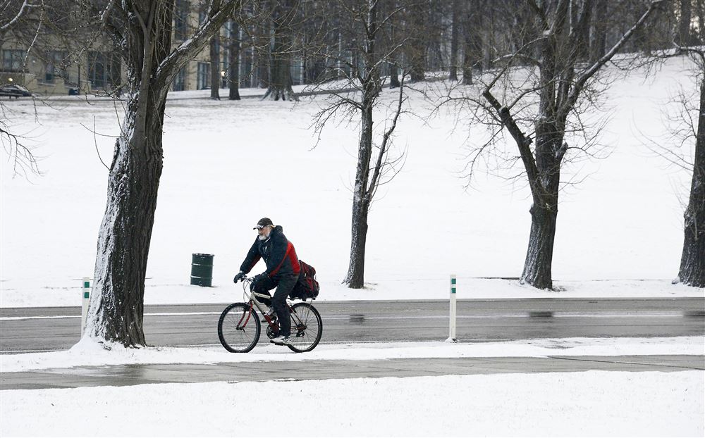
The biker in the pic for the Anchorage article is badass.
Comments are much like elsewhere. Like, that tax money I pay that goes to roads is somehow no good because a car user might pay a pittance more for cruising in his death machine.
Note: Excllent cameo in teh comments by one Bill Edmonds - complete with snowly profile pic to fit in with the natives.
mick
2015-01-28 11:54:59
I would be interested in a winter bike fest
sgtjonson
2015-01-28 16:01:15
A winter bike fest would be awesome.
vannever
2015-01-28 18:50:13
erok
2015-01-29 10:58:22
erok
2015-01-29 11:11:39
marko82
2015-02-02 11:19:59
PG:
Negley Ave Bridge replacement planning begins
Actual construction not likely to happen until 2018, but now's the time to start making noise about what we want it to look like.
epanastrophe
2015-02-02 22:55:46
@ B B
New Bridges- could be a lasting legacy for Peduto.
mick
2015-02-02 23:07:18
On a vaguely related theme, there's a map that indicates what roads get some amount of federal support.
This is the view for the Pittsburgh area:
https://api.tiles.mapbox.com/v4/enf.ee407c6a/page.html?access_token=pk.eyJ1IjoiZW5mIiwiYSI6IkNJek92bnMifQ.xn2_Uj9RkYTGRuCGg4DXZQ#12/40.4590/-79.9432
The roads in yellow are part of this system (if I understood it).
The blue roads are from
OpenStreetMap
An article where I found this:
https://www.mapbox.com/blog/hpms-openstreetmap/
Anyway, check out what's funded. It's not totally intuitive.
ahlir
2015-02-03 11:01:12
The traffic counts are eye-opening. Perry Highway near my house gets more than double the count of the Mon-Fayette Expressway in its busier, northern section (16,758 vs. 7,638). The less busy southern section gets only a bit more traffic than Perrymont Road (6,176 vs 4,675). Even Babcock and Siebert are in five digits. I-279 near the city is over 50K.
Thank you for finding this!
stuinmccandless
2015-02-03 13:54:36
Interesting that vehicle count is slightly higher for Penn Ave through the Cultural District than it is for Liberty Ave along that same stretch. The latter road has always seemed busier to me, especially since Penn is pretty empty during non-rush hours and when there are no large events nearby.
chrishent
2015-02-03 15:15:20
I'm not sure I believe that Ellsworth gets much more traffic than Penn and Liberty downtown combined. I wonder how and when PA accumulated this data. It shows cars going down Forbes and right through Market Square, which suggests it may be pretty outdated. (The map data is supposed to be from 2012, but I don't think Market Square has had through traffic since at least 2009.)
steven
2015-02-03 16:33:10
I agree that some of the volume data might be off, not to mention the dates (I guess you'd have to dig into the specifications for the map data).
But what I found interesting was the funding patterns.
Like why is Wilkins there, but just between 5th and Beechwood (with a snippet at Dallas)?
And Ellsworth between Neville and Highland?
And various other bits and pieces in residential areas.
Or maybe I'm just confused. The data are probably there to be able to click through to a project description (if someone put it together).
Or maybe we are witnessing the power of pork?
ahlir
2015-02-03 17:16:21
As I read the map, the entirety of Wilkins has a yellow line (though east of Beechwood it's a thin yellow line because there's supposedly so little traffic).
I agree that the map shows no federal aid for the part of Ellsworth east of where it goes under Highland. Perhaps it's something simple, like certain blocks at one time got improved curb cuts or street lights that the feds helped to finance, and other blocks didn't.
steven
2015-02-03 19:32:16
Yeah, @Steven, maybe I was just trolling. But this stuff doesn't quite make sense, does it? How is it that some short bits of road get subsidies but others don't? The bit at Dallas is particularly interesting. The eastern side of the intersection (subsidized) is in pretty good shape, but the western side (not) is a total mess; I can't bike through it except very slowly. What is that about?
While we're on the subject, what's with 45th in Bloomfield/Larryville (or St. Francis, as I always thought it was)?
ahlir
2015-02-03 21:44:32
Dallas, Wilkins, and Beeler were once part of US-22/30, fwiw; ancient road signs still stand at Dallas & Penn and on Beeler at Forbes...
epanastrophe
2015-02-04 00:19:31
You may be reading too much into the situation at Wilkins and Dallas. The federal data neglects one side of the triangle there, but it could just be that they're not focused on such small details (just like how they only try to map one direction of a divided highway). The federal version of the intersection just shows Wilkins and Dallas intersecting, and exactly how isn't intended to be part of the representation. They seem to also neglect various ramps and connectors to highways that surely got federal bucks. (And the map seems to show that both eastern and western sides of the triangle got federal funds; it's the southern side that didn't.)
The map shows a high number of vehicles for 45th, but without more information on where these numbers all came from, I wouldn't put much stock in it either.
steven
2015-02-04 00:25:03
marko82
2015-02-05 10:06:36
How cool is this?
The keynote speaker for 2015 Miami Valley Cycling Summit will be Mayor Bill Peduto of Pittsburgh
http://www.dailycall.com/news/news/151739760/Cycling-Summit-coming-in-May
marko82
2015-02-10 10:06:29
chrishent
2015-02-10 12:46:37
marko82
2015-02-12 09:18:02
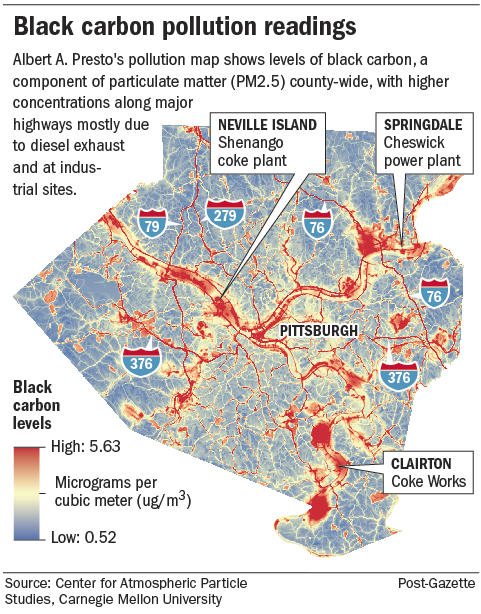
"Pollution concentrations in river valleys, he said, should raise public concern about parks, bicycle trails and recreational facilities along the rivers, he said."
http://www.post-gazette.com/news/environment/2015/02/11/Carnegie-Mellon-University-professor-makes-new-pollution-maps-public/stories/201502110023
ka_jun
2015-02-12 10:40:29
In the PG's Photos of the Day:
rustyred
2015-02-13 07:46:37
The pollution mapping story is us -- Albert was my first PhD student and returned to our faculty a few years ago. If anybody has questions about it I can probably answer them.
neilmd
2015-02-13 10:24:43
Short blog post on the iCycle blog on the Trib about the Wheel Mill:
http://blog.triblive.com/icycle/2015/02/12/the-wheel-mill/
chrishent
2015-02-13 10:30:24
marko82
2015-02-13 10:56:30
@neilmd If anybody has questions about it I can probably answer them.
OK. Are there many times when it would be contrary to your health to excercise on the bike trails?
Of course, unpolluted exercise is eetter, but if, say you did 30 miles on the GAP out and back 3 X a week, how many times you would be healthier to just skip it?
The answer has to be "some". Once when Clairton works tar-capturing technology on the ovens failed , I detoured about 15 miles to avoid DRIVING through the dense black cloud that drifted across the river.
So the question is how often it would happen.
mick
2015-02-13 12:47:12
I'm pretty sure that you would always be healthier doing 30 miles on the GAP than not.
For most healthy adults, the answer is probably that the cumulative effect on your lungs is fairly linear with the cumulative product of volume of air and pollution level (some aggregate of fine PM and ozone). Breathing really hard at VO2max next to a failed coke oven is in fact probably not the best idea -- lung tissue does recover, but never completely (by the way for any smokers out there don't worry about air pollution until you quit).
We had an event downtown in Dec organized by Power of 32 and local foundations addressing energy in the region, and both I and a keynote speaker, Aaron Bernstein from the Harvard School of Public Health addressed pollution and climate issues. He is an MD and also an avid cyclist, and has tracked his lung volume over time as he has biked in Boston and elsewhere, and reports that he can detect a loss in lung volume related to pollution exposure.
My advice is that yes it is good to plan routes to reduce exposure to pollution, but there are very few cases where it would be a net disbenefit to go out on a ride. The jail trail is an interesting one in that regard, where again it is surely good for your health to ride along it but it could be better. We should probably play pretty close attention to trees and other plantings that can shield the trail from the parkway.
neilmd
2015-02-13 17:52:28
Re the 2/11 air quality forum, here's my comment on that
Post-Gazette article.
At the forum on the 11th, I asked how the map (pictured here) was created, and Presto said that they used measurements from 70 sites around the county, collected at (I believe he said) various times of day and times of the year. It also appears that they modeled or simulated the pollution near the major freeways and roads (the web of red lines). So it sounds like the map is an approximate picture of pollution, since the values displayed at most points are interpolated from the 70 sites.
I was surprised that the pollution "clouds" around Dravosburg and Elizabeth are bigger than that around Clairton, on this map; I expected the opposite. I also expected to see the prevailing winds more visible in the data, e.g. the pollution from Clairton blows to the east. Hopefully the measurements will be more dense in coming years and we can get more accurate maps, and learn how the pollution changes day by day.
For time lapse video of Pittsburgh pollution, see
http://breatheproject.org/learn/breathe-cam/
paulheckbert
2015-02-15 01:44:06
@neilmd: Do you know how that map was created, and how accurate it is? Thanks.
paulheckbert
2015-02-15 01:46:17
I'm also wondering about that 70 sensor thing. The grid on the map is way finer than that suggests. And I don't see how interpolation would give you that. Were the sensors moved around over the course of the study? Are other data incorporated? Inquiring minds...
What's the citation? Now that I'm wondering about it.
ahlir
2015-02-15 17:00:58
Dense measurements would be wonderful! They would also be really, really expensive. There are interesting tradeoffs between lots of cheap (aka crappy) sensors and a few good (aka expensive) suites of instruments, but the way these data were obtained was with an instrumented van that parked at those 70 sites a few times over the course of about a year. There are other measurements going on out of Pitt that involve a bunch of instruments mounted on light poles (30 or so) that don't move (much). Those data are not part of this study.
The maps are produced via a technique known as "land use regression" (LUR), which makes use of Geographical Information Systems (GIS) databases for those enquiring minds that tend toward speaking geek. It is not so much as a model as an informed extrapolation. The postulate here is that the pollution (mostly black carbon, aka "soot", which is part of fine particulate matter) comes from two major sources: industry and transportation, and also may tend to be trapped in river valleys and thus is likely to correlate with elevation around the county. GIS is then used to generate "buffers" that relate any of the 70 sets of measurements to (1) how close to a major roadway (or the integral of traffic volume or other similar measures of proximity to vehicles) (2) how close to a known industrial site with registered emissions and (3) whether the site is above or below a cutoff that pretty well says "river valley". The model then does a best fit job of explaining the observations based on this fairly crude set of criteria. It is standard practice to "train" the model on a subset (typically the majority) of the data but to hold a set out for "validation" -- you want to make sure that the model extrapolates well to points where you actually do know what was observed.
LUR is used fairly frequently in epidemiology to try to do better than relating health outcomes to a few datapoint from central site monitors (i.e. the health department in Lawrenceville).
The bottom line is that big industry is certainly a contributor, but vehicles are probably equally an issue -- almost certainly if we start looking at population weighted exposure -- and also smaller business and industrial activity is a non-trivial contributor.
neilmd
2015-02-16 18:54:24
Got my layers on, gotta slog home in the relatively balmy evening...
neilmd
2015-02-16 18:54:58
Ok.
The map was produced using a detailed model of how geographic factors (elevation, vegetation) plus data on human activity (traffic, factory emissions) and maybe weather patterns (prevailing wind) affect pollutant distribution.
The model is then anchored to observations collected by the mobile sensors (where sampling points were presumably chosen to maximally constraint its parameters). It also sounds like you used deleted interpolation to validate the model.
So, I dunno... sounds good enough for me.
But the implication is that all our river trails may not be so good for our health. Put another way: climb often, climb high.
ahlir
2015-02-16 21:32:32
I would never argue with "climb often, climb high".
Still, for everyone who is otherwise healthy, the health benefits of riding even through the reddest parts of that map outweigh the negatives by a lot.
If you want to plan, however, consider the meteorology a bit. The river trails are going to have the highest pollution levels when there is little wind and the air is stable; that's when you get inversions that cap air in the valleys. In practice that means a still morning before sunrise (when there is usually enough heating to stir air up out of the valleys) and especially during the morning rush. Sounds like Stef at 5am to me...
In that case, the benefits of a good hedge are not to be sneezed at; it might be interesting to think about plantings along the jail trail -- who wants to see the cars anyway?
It would be quite cool to figure out how to assimilate tiered data with lots and lots of low quality data (think the GASP bike monitors, etc), a fair bit of medium quality data (like these mobile van data) and a little (continuous) high quality data (takes about $1M worth of kit in a permanent station). We are actually working on that, though maybe in Beijing before Pittsburgh.
neilmd
2015-02-17 06:29:08
So long as plantings along the trails don't grow in to the trails frequently. I've called 311about the overgrowth on panther hollow and connecting trail to saline st bike lane.
Dumbest installation of hedges ever is by kelly's bar and lounge on center ave. They put hedges right next to parking spaces where people exit their vehicles, with zero setback. This is especially annoying when the hedges become snow covered.
benzo
2015-02-17 09:55:31
I'd really appreciate not having plantings on the south side of the trails. The icy parts are always the places where there's shade. Or use deciduous plants.
jonawebb
2015-02-17 10:00:24
I don't know what you'd do with those stretches of EFT where there is zero horizontal space between trail and parkway. Frankly, I'm more worried about a car flying down the EFT 60 mph on its roof than any air pollution.
stuinmccandless
2015-02-17 11:43:36
It would be quite cool to figure out how to assimilate tiered data with lots and lots of low quality data
I agree.
One more question:
Are you set up to generate a temporal sequence from the data?
I'm thinking of an animation that shows a 24h cycle, say for workdays and for weekends. I can see this being really useful for people planning their riding (and more generally as a policy input).
ahlir
2015-02-17 11:51:58
@Stu: There might be alternatives, say a low wall topped by a transparent glass barrier (if there is such a thing that's vandal proof).
ahlir
2015-02-17 11:56:25
"Frankly, I’m more worried about a car flying down the EFT 60 mph on its roof than any air pollution."
I'm so glad I'm not the only one who's had nightmarish scenarios like this run through my head.
I envision being chased down the EFT by a tanker truck filled with fuel... jack-knifed, overturned and bursting into flames.
That, or corn syrup.
rustyred
2015-02-17 12:03:24
@stu Frankly, I’m more worried about a car flying down the EFT 60 mph on its roof than any air pollution.
The first few times I was on the Jail Trail, I was freaking out. Standard procedure if I hear a car coming up behind me at 70+ mph, on Forbes or Liberty, say, I kind of dive for the sidewalk, without even looking.
I have to recalibrate my ears to ride on the Trail.
mick
2015-02-17 12:15:00
I completely agree that of the hazards to cyclists in Pittsburgh, air pollution probably ranks fairly low. That being said, 3 of the top 10 causes of mortality in the global burden of disease have to do with breathing fine particles (breathing over a 3-stone open cooking fire, not a common problem in Pgh; breathing through a lit tube filled with tobacco, a fairly common problem in Pgh; and just breathing).
Something like 1-2% of deaths in the US are attributable to #3, which is the topic of conversation here. More relevant, probably, is something near 10% of heart attacks are associated with #3. So, is a cyclist more likely to have a heart attack or to be doored? In spite of the alarming proximity of fast cars on the EFT, that does not rate high on my risk list. Hitting the middle bollard by the rental station, now THAT is on my list. I've been known to go through that gate at a pretty good clip.
neilmd
2015-02-17 14:21:54
> Hitting the middle bollard by the rental station, now THAT is on my list. I’ve been known to go through that gate at a pretty good clip.
For what it's worth, I asked a couple council offices a couple years ago to see about removing the bollards at the rental station and the gates on the Panther Hollow Trail, and didn't get much response beyond 'we'll look into it', and also discussed it with Planning Director Ray Gastil at a meeting last fall. Maybe it's time to try again.
epanastrophe
2015-02-17 14:36:10
I bike up East and Evergreen fairly often. I don't worry about getting hit by a bus very much, let alone one rolling down the hillside off I-279. Cars going sideways on the Parkway are hardly a rare occurrence.
Then again, I'm riding right alongside or following cars/trucks/buses in traffic everywhere, so the monoxide and soot coming off passing traffic on I-376 do not strike me as that big a deal.
I think what I'm saying is that I don't give a hang about air pollution so much as getting hit by stupid drivers, and not because they aren't looking, but because they were going to wreck anyway and I just happened to be in the wrong place at the wrong time. We have plenty of evidence that getting your hair done in a salon or buying gum in a convenience store are also good ways to get hit by a car.
stuinmccandless
2015-02-17 16:41:48
While I share the gut reaction that cars are a much bigger concern than pesky sub-micron particles (pun semi-intended), the data are ambiguous.
Let's start with dying, as that tends to focus the mind. There are about 700 cycling deaths per year and about 70,000 deaths attributed to breathing fine PM pollution. So, if about 1% of people are active cyclists, the two numbers are at least in the same range. Of course that ignores all sorts of obvious things. People tend to breathe all the time but unless they are Danny Chew or crushing the commonwealth like Stef they don't tend to be on a bike actually all the time, and it is also probable that cyclists are on the whole healthier and less likely to have cardio pulmonary deficits. I have no idea how many heart attacks occur each year while people are either on a bike or just rode, but I suspect the number is pretty small, in spite of the zany things my heart monitor does when I go up Dornbush. Bike accident fatalities have a mean age of 43 and it is probable that the PM fatalities occur mostly in people older than that (but NOT in people who were about to die anyway -- the epi people call that "harvesting"). etc, etc, etc.
If you go beyond dying (or maybe stop short of dying is a better way to state it...) you wind up comparing road rash, concussions, etc to reduced lung function, etc. In this case it is very likely that cyclists really do suffer more damage than your average person, simply because we gulp so much air. I would not be at all surprised if we sustain more injury from breathing crappy air than we sustain from being hit by things.
Risk perception is a funny thing. We famously over estimate risk from alarming but unlikely causes and underestimate it from quotidian stuff. In this case, winding up on someone's windshield may be the alarming one while breathing may be quotidian. Again, I am not arguing that anybody should tone down the vehicle safety conversation -- I squawk at the 2' passes as loud as anybody -- but air pollution remains a big deal.
neilmd
2015-02-18 09:37:19
Also less than 1% of people are active cyclists. I think there are somewhere between 500K and 1M bicycle commuters. Even if you add in some recreational cyclists who don't commute you don't get near 1%.
Also, this brings up another thing, which is that we really need a comprehensive national survey of cyclist health and behavior in this country. The last good study is over 40 years old now. It's very hard to evaluate safety issues based on a study done when cycling is so different. We need something that looks into the causes of accidents, into how many people are putting in how many hours on a bike, into the effect of bicycle infrastructure and personal safety items like lights, helmets, and reflectors, etc.
jonawebb
2015-02-18 09:52:46
Pittsburgh-
Bus meets bike: How the next wave of commuters is changing the urban landscape
http://www.popcitymedia.com/features/partthreetransportfeature_021815.aspx
marko82
2015-02-18 10:16:54
@jonawebb we really need a comprehensive national survey of cyclist health and behavior in this country.
True that.
mick
2015-02-18 11:42:08
If you aren't especially concerned about our air pollution, go somewhere with clean air and go for a ride. I'm always blown away by how nice the air is when I visit family in rural Oregon. It feels luxurious to breathe there and it's much more comfortable to really gulp in the air. There's no doubt our pollution is doing harm. I don't expect to die early from cycling here for any reason, but that doesn't excuse our serious problems with both air and safety. Clean air and not being murdered by other people are both considered human rights according to the UN.
richierich
2015-02-18 13:34:40
I agree rich. I ride up in Warren County sometimes and the air is sweet smelling and wonderful. Here it is just one big smog/diesel pit. Sure is sad, but we love our big SUV's and we love our coal, so not much anyone can do about it.
gg
2015-02-18 14:27:06
marko82
2015-02-20 10:58:16
I rode through downtown last night at rush hour. The air was not luxurious.
mick
2015-02-20 12:05:04
"If you aren’t especially concerned about our air pollution, go somewhere with clean air and go for a ride."
Alternatively, ride through Glassport some mornings when the whole town smells like burnt plastic...
sgtjonson
2015-02-20 12:24:49
ka_jun
2015-02-24 08:33:10
marko82
2015-02-25 10:10:28
Study finds pedestrian deaths up 40% in Pa
No mention of cyclists. The mishmash of statistics at the end of the article is the short that drives me nuts. For example, "Four states — California, Texas, Florida and New York — accounted for 43 percent of U.S. pedestrian deaths in 2013." Any guesses on what four states are the most populous in the US? However, they account for almost exactly 33% of the population, so they are as a group somewhat more dangerous than average.
neilmd
2015-02-28 09:37:43
Trib article on the East Ohio St bike lanes:
http://triblive.com/mobile/7936229-96/bike-lanes-east
A bit surprised that there continues to be no news on the trail being built along PA28. It could connect nicely to these bike lanes
chrishent
2015-03-17 06:29:08
ahlir
2015-03-17 08:18:19
jonawebb
2015-03-17 08:32:53
> A bit surprised that there continues to be no news on the trail being built along PA28. It could connect nicely to these bike lanes.
This is the first I've heard of that being a 'trail', rather than just a replacement of the previous sidewalk along the highway...
epanastrophe
2015-03-17 08:40:49
@buffalo, you may be right. My statement was based on something that was said on another thread (
http://localhost/mb/topic/penndot-east-street-meeting-march-5th/#post-309425). But then, the last post on that thread refers to a news release which describes it as a "wider walkway". I'm not familiar with what was there before, but it probably would have been somewhat easy to add a trail there.
chrishent
2015-03-17 08:55:29
If you see this please turn it in. Last seen in New Brighton, Beaver County, so it may turn up on the next rando:

It
"doesn't pose a public health threat unless it's broken open, tampered with or otherwise damaged." So don't do that.
jonawebb
2015-03-19 10:00:28
Didn't something similar go missing off the back of a truck last year too? These contractors need to keep better track of their toys.
BTW, google says it's a Surface Moisture-Density
Gauge
marko82
2015-03-19 10:23:13
chrishent
2015-03-19 12:08:39
chrishent
2015-03-19 18:54:58
Another article on the new Envision Downtown initiative, from the Trib:
http://triblive.com/news/adminpage/7991843-74/downtown-partnership-pittsburgh#axzz3Uvcjkn3L
This one focuses more on the big picture of this initiative, and makes no mention of additional bike lanes downtown. Surprising, really.
chrishent
2015-03-20 07:36:45